
Records
Your search returned 404 Results
Refined by : Special Collections Geolocation
- Iconographic browsing
- Results per page : 50
-
 Emptying Pig Iron from Molds into Car, Pittsburgh, P.A.
Emptying Pig Iron from Molds into Car, Pittsburgh, P.A.
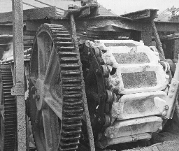
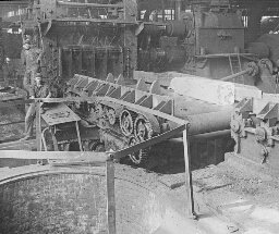
In view No. 63 you saw the pig iron machine at rest. You viewed it from the end at which the blast furnace stands. You were looking toward the freight cars on the switches in the distance. In these cars, you will recall, the pigs are dropped. This view shows you the opposite end of the pig iron machine. Directly in the foreground and below the machine is the freight car. The first thing you will observe are the great cog gears that turn the spindles about which the pig iron belt revolves. You will observe the heavy steel chain that holds the cast iron boxes in place and yet allows them to revolve about the wheel. This chain is made of links composed of two strips of steel, one on either side of an iron spool. These little spools fit into the cogs on the spindle, and the two steel bars connecting them fit nicely over each cog. You also have here a very distinct view of the cast iron pigs. The three molds at the top of the spindle contain pig iron. Those below have dropped their bars into the car. Most of the pigs fall out of the troughs of their own weight. Occasionally one sticks fast so that it must be tapped to release it. The big hammer, the end of which you see, is to loose these occasional pigs. The entire pig iron belt is about 200 feet long. That is, the car is about 100 feet from the blast furnace. The belt moves very slowly, but not slowly enough to allow the pigs to cool thoroughly by the time they reach the car. Hence water is sprinkled over them by automatic (ô´ t-mt´ k) sprinklers as they pass along. Imagine yourself the man standing in this car. Give a brief talk explaining your duties. Keystone ID: 6531 Note: All titles, descriptions, and location coordinates are from the original Keystone Slide documentation as supplied by the Keystone View Company. No text has been edited or changed. -
 Line of Sand Dunes, Columbia River, Oregon
Line of Sand Dunes, Columbia River, Oregon
On your right in the view flows the Columbia River. On the river bank is a railroad track. To the left of the track is a slender barrier made of boards. This barrier has been built to prevent the sand from burying the railroad tracks. The dunes are low and hills stretching straight ahead of you in the center of the view. The sand is blowing so violently that the foreground of the scene looks like a heavy dust cloud; and it is flying with such force that the man is protecting his face with his hat. Sand dunes are formed like snowdrifts. Perhaps you have seen the wind pick up the snow in great swirls and pile it in drifts along fences. You have seen dust clouds carried by a gale. If you put in the place of the snow or the dust a great stretch of sand, you would have a sand storm, and a sand dune would be formed. In some parts of the world these dunes are from 200 to 300 feet high. But they are usually only from 10 to 20 feet. The dunes usually start about the stump of a tree, a house, or anything solid. Once it is started, the sand continues to gather until a ridge is built. There is a natural limit to its height. The upper wind is stronger than the wind next to the earth, so that after a dune has reached a certain height. The upper wind is stronger than the wind next to the earth, so that after a dune has reached a certain height the wind tears its top off and carries the sand beyond. In many places forests have been the barriers. The dunes may kill the first line of trees; then shift farther into the forest until a great wooded area has been deadened. In some places the dunes have marched over great areas of land that has been tilled, making it useless. On the shores of the Baltic Sea towns have been wiped out by the march of the dunes. Explain how sand dunes are formed. Keystone ID: 6228 Note: All titles, descriptions, and location coordinates are from the original Keystone Slide documentation as supplied by the Keystone View Company. No text has been edited or changed. -
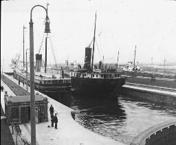
 Great Ocean Liners at the Docks, Hoboken, N.J.
Great Ocean Liners at the Docks, Hoboken, N.J.
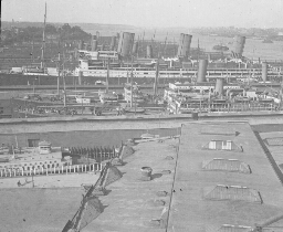
When a traveler comes into New York harbor his attention is claimed by a number of things. Undoubtedly the first point of interest is the high buildings of Lower Manhattan. Then he turns for a look at the Statue of Liberty and Ellis Island. As he goes farther northward towards North River (the lower course of the Hudson), he sees an equally wonderful sight. It is the shipping on the Jersey and Manhattan shores of the North River. On the southwest shore of New York Bay lies Bayonne, N.J. Jersey City is on the west shore of North River opposite Lower Manhattan. Hoboken lies just north of Jersey City-with no real dividing line between the two cities. In effect there is one great city from Bayonne for 15 miles north on the west bank of the Hudson. These cities are admirably located for steamship traffic. They have New York harbor on front of them and a great railroad connection back of them. Most of the railroads leading into the City of New York end on the west shore of the Hudson. Hoboken has a population of 67,611 (1915). It is the most densely populated city in New Jersey. It is the terminal of the Delaware, Lackawanna and Western Railroad; and Jersey City just below it is the terminal of the Erie and the Jersey Central and the freight lines of the Pennsylvania. The steamship lines whose boats put in at its piers are the Hamburg-American, North German Lloyd, Netherlands-American, and Thingvalla. These large vessels are German liners which took refuge in this harbor when the Great European War broke out in 1914. They stayed at their piers to avoid being captured. Keystone ID: 16762 Note: All titles, descriptions, and location coordinates are from the original Keystone Slide documentation as supplied by the Keystone View Company. No text has been edited or changed. -
 Niagara Falls in Winter, Niagara, New York
Niagara Falls in Winter, Niagara, New York
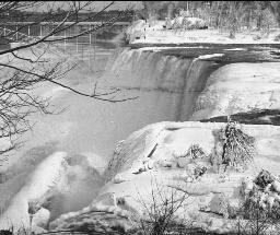
Most people see the Niagara Falls during the summer. This is because most of us take our vacations during the summer months. The falls are worth seeing any season of the year; but they are most wonderful in the winter. You are here looking from Luna Island toward the American falls. A large part of the surface where the water is shallowest is covered with a sheet of ice and snow. The heavier parts of the falls are almost free from the touch of winter. At our backs are the Canadian falls which carry nine times as much water as do the American falls. At the end of the bridge is a tunnel which leads to the big electric power plant a quarter of a mile down stream. In this power plant are installed the great turbine generators which produce almost a half million horse power of electrical energy. This electricity runs the street cars of Buffalo, Syracuse, and other cities in New York, and is transmitted to Cleveland. Father Hennepin was the first white man to see Niagara Falls. He discovered it in 1678. LaSalle built a fort here in 1679. During the war of 1812 many battles were fought about Niagara. The state of New York has reserved 107 acres as a park on the American side of the Falls. Canada has a larger reservation on the Ontario side. On the banks of Niagara Falls is located the city of Niagara Falls. This city has a population of about 43,000 (1915). It is 16 miles north-northwest of Buffalo. Niagara falls has become a great center for manufacture of wood pulp, paper, chemicals, and prepared foods. Several trunk lines of railway cross the Niagara River at this point. The electric power furnished by the Falls adds greatly to its importance. Keystone ID: 171 Note: All titles, descriptions, and location coordinates are from the original Keystone Slide documentation as supplied by the Keystone View Company. No text has been edited or changed. -
 View of Stockholm, Sweden
View of Stockholm, Sweden
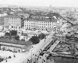
Before you is a bird's-eye view of the capital of Sweden. A part of the water front of the city is to your right. And what looks like the street is more nearly a bridge; for there is water to the extreme left also. All about the city are waterways. For this reason Stockholm is called the "Venice of the North." But the Venice of Italy is built on piles. Stockholm is set upon natural granite. Water and stone abound in Sweden. One acre out of every twelve in the whole country is water, and the granite breaks out in its highlands. Stockholm is an important seaport on the Baltic. Like many other Baltic ports its waters are frozen in winter; but many flags fly in its harbor in the shipping season. The city is the seat of government and an educational center for the country. It has many factories, cotton and linen mills, iron foundries, and sugar refineries. It is about the size of New Orleans. Do you know what we get from Sweden? Its forest supply matches, woodenware, and paper, and its mines furnish high-grade iron. The Swedes are a thrifty, hard-working people. They raise many cattle and sheep, and make butter and cheese. Potatoes, rye, sugar beets, and oats are grown on the small farms. Stockholm is an old city. Its history can be traced for more than 700 years. Out of the gates of its ancient castles marched many armies to battle against the Germans, the Danes, or the Russians. Under two of its kings, Sweden was one of the chief powers of northern Europe. Then Stockholm was the queen city of the Baltic. Keystone ID: 13000 Note: All titles, descriptions, and location coordinates are from the original Keystone Slide documentation as supplied by the Keystone View Company. No text has been edited or changed. -
 Market Scene, Cologne, Germany
Market Scene, Cologne, Germany
Cologne (k-ln´) is the largest German city on the Rhine, and the chief German port on this river. It has a population of over 500,000. It is a first-class manufacturing center, and one of the strongly fortified cities of the empire. A garrison of about 8,000 men is stationed here all the time. The city gets its name from the Latin word "Colonia", given it by the Romans, because it was a military colony or center, formed by the wife of the Roman emperor, Claudius, in 50 A. D. It soon was made the capital of the Roman province called Lower Germany. During the 13th, 14th, and 15th centuries it was one of the most powerful cities in all Europe. It was a great cloth-weaving center, and carried on heavy trade with neighboring cities and countries, particularly with London. Its commerce of to-day is so important that 5 1/2 miles of wharves have been built along the banks of the Rhine. Across the river there is a bridge of boats. It is made of barges, lying side by side, with boards covering them. Sections of the bridge move out of the way to permit the passage of river boats. The city has important machine shops, and manufactures woolen and cotton goods, carpets, cigars, tobacco, chocolate, candles, soap, and perfumery. The perfumery is named after the city-cologne. The chief single point of interest is the great cathedral. This was begun in 1248, and finished in 1883. It is one of the finest specimens of Gothic building in Europe. It is 570 feet long, 200 feet wide, and the towers are 515 feet high. The market scene here shown is chiefly of interest because of the large number of women. The German women do their own gardening, carry the produce to market, and sell it. For what is Cologne noted? Keystone ID: 2002 Note: All titles, descriptions, and location coordinates are from the original Keystone Slide documentation as supplied by the Keystone View Company. No text has been edited or changed. -
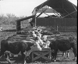 Feeding Hereford Cattle, Manhattan, Kansas
Feeding Hereford Cattle, Manhattan, Kansas
This is a fine herd of Herefords. They are all thoroughbreds that are being made ready for market. These cattle get their name from the county of Herefordshire, in England. Here the breed had its beginning. Herefords came from a stock that had long been used for pulling heavy loads. Hence, they have heavy necks and shoulders, and thickset legs. Henry Clay, of Kentucky, brought the first Herefords into America. For the last 40 years they have been a popular breed among the farmers and cattle raisers of the Middle West. This breed of cattle takes on flesh readily, they are hardy, and their flesh is of fine flavor. They are a good beef cattle. Shorthorns are the heaviest of the beef breeds. Herefords rank next in weight. Stockmen have found that it is more profitable to feed beef cattle for the market while they are young and growing. Corn is the principal food used in the feeding of cattle that are being prepared for market. Many cattle ranches and cattle ranges are found throughout Kansas, Nebraska, and the Dakotas, and also on the plains of Oklahoma and Texas. The corn belt extends from Ohio, through Indiana, Illinois, Iowa, and Missouri, to central Kansas and Nebraska. It follows naturally that the corn belt should also be the center of the stock-raising industry. Much alfalfa is grown in these states, and this is also an important factor in stock feeding. The long, narrow troughs from which the cattle are feeding, are filled at regular periods with corn, oil-meal, and other fattening foods, and the cattle come to their meals as regularly as we go to ours. The large shed in the background contains alfalfa. This the cattle may eat at any time they wish. Keystone ID: 16710 Note: All titles, descriptions, and location coordinates are from the original Keystone Slide documentation as supplied by the Keystone View Company. No text has been edited or changed. -
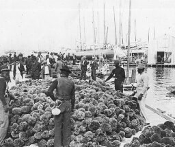 Sponge Market, Key West Harbor, Florida
Sponge Market, Key West Harbor, Florida
The "sponges" that are sold are only skeletons. Sponges are animals that attach themselves to rocks on the bottoms of warm seas. The openings in the sponge which you buy are, in the live sponge, filled with soft jelly-like matter. This soft substance can be readily squeezed out. Divers collect the sponges from rocks, with long rakes or hooks. These sponges are put into boats, carried to the shore, and there left until the jelly-like matter decays. Then they are washed, dried, sorted, and shipped to market. It is one of these markets at Key west that is here seen. You will observe that the sponges shown are round in shape. This is because their long ends have been trimmed off. Many of the finer varieties are bleached before marketing. Sponges are found in many parts of the world in warm seas. But there are only a few places where sponge fishing is profitable. The best known of these are along the eastern shores of the Adriatic Sea, and off the coast of Greece and Asia Minor and parts of Africa. In the Western Hemisphere the chief sponge fisheries are off the Florida coast and among the Bahama Islands. Key West is a city of 20,000 inhabitants on the most westerly of the Florida Keys, or islands, in the Gulf of Mexico. Its chief industries are the manufacture of cigars, fancy shellwork, and sponge factories. The city has a great harbor which the government has fortified. Key West is a well-known winter resort. Its most interesting feature is the railroad which leads from the island to the mainland of Florida. This road bridges great stretches of the open gulf, and is the only railroad that is largely built over the waters of the ocean. Keystone ID: 9175 Note: All titles, descriptions, and location coordinates are from the original Keystone Slide documentation as supplied by the Keystone View Company. No text has been edited or changed. -
 London Bridge, London England
London Bridge, London England
There is a number of bridges in London across the Thames. Beginning upstream they are in the following order: Westminster, Waterloo, Blackfriars, Southwark, London, and Tower. This list does not include several railroad bridges. The oldest and busiest of the bridges named is the London Bridge. It was completed in 1831. It is 928 feet long and 63 feet wide. It consists of 5 arches built of granite. The lamp posts that are on the bridge are made of the cannon the English once captured from the French. The traffic on the bridge is heavy at all times. It is bewildering to a stranger on a Bank Holiday. Every day more than 100,000 people walk over the bridge, and more than 20,000 vehicles cross it. You can figure for yourself the amount of traffic it carries in a single year. Nobody knows when the first bridge was built across the Thames near the place where London now stands. But there has been a London Bridge since 1209. The old bridge stood below the present one. It had houses on it in which many people lived. When Elizabeth was Queen of England, the Lord Mayor of London lived in a house on London Bridge. This same Lord Mayor's daughter fell off the bridge into the water. A young servant of the Lord Mayor leaped in and saved her. Of course they were afterwards married, and the young man became the Earl of Leeds. One of the customs of earlier days does not make such a pleasant tale as the love story. Kings and queens were powerful then, and the heads of their courtiers were not very safe. A man might be imprisoned in the Tower one night. Next day his head would be fixed on a spike on London Bridge. The skulls were warnings to all evil-doers. Keystone ID: 2101 Note: All titles, descriptions, and location coordinates are from the original Keystone Slide documentation as supplied by the Keystone View Company. No text has been edited or changed. -
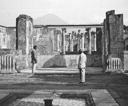 Mt. Vesuvius Seen from the Ruins of Herculaneum, Italy
Mt. Vesuvius Seen from the Ruins of Herculaneum, Italy
Mount Vesuvius (v-s´v-s) is about ten miles southeast of Naples. It is less than 4,000 feet high. It is the only active volcano on the continent of Europe, and is one of the most interesting in the world. It is a vast area of lava, sand and ashes. No grass or shrubbery grows on the mountain sides. Before 79 A. D. this mountain was covered with farms and gardens. Great grape vineyards, for which Italy is famed, grew on its sides and in the valley below. There were hot springs on the edge of the mountains, and the district roundabout was a favorite health and pleasure resort for the wealthy Romans of that age. Among the fashionable resorts near by was Herculaneum (hûr´kû-l´n-m). On August 24, 79 A. D., suddenly great volumes of steam, hot mud, ashes, and burning rocks were belched forth into the air from the top of Mount Vesuvius. So great was this eruption that the mud and smoke and rocks hurled into the air shut out the light of the sun and even in Rome, 190 miles north of Mount Vesuvius, the day was turned into darkness. Great rivers of molten rock, ashes and mud flowed down the mountain side, burying the farms, gardens and cities completely. In 203, 472 and 512 A. D. there were other eruptions. Then it was quiet for many centuries during which the mountain sides, even to the crater's edge, became overgrown with forests. In 1631 there was another eruption and in the eighteenth and nineteenth centuries many more, the last one being in 1906. This eruption blew off the top of the cone, made the mountain much lower and completely changed its shape. Much of Herculaneum has been unearthed and we have been able to see just how the people of that day lived. Keystone ID: 7283 Note: All titles, descriptions, and location coordinates are from the original Keystone Slide documentation as supplied by the Keystone View Company. No text has been edited or changed. -
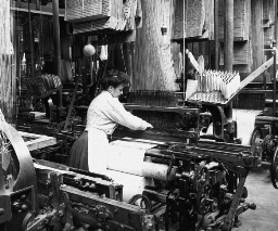 Weaving Linen Fabric, Montreal, Canada
Weaving Linen Fabric, Montreal, Canada
After the bobbins are filled they are sent to the weaving room. You can see a number of looms busy weavin When sugar beets are pulled, their tops are cut off, and their roots are stacked in great piles. Sometimes these piles are made in the fields where they are grown, and the beets are hauled later to the sugar factory. Such piles are to be seen frequently in Colorado, where there is little rainfall. The heaps are often higher than a man's head, and cover large areas of ground. The roots must be stored indoors before frost comes. They usually are hauled to the factory, where they are dumped into bins such as you see. The beets here have been unloaded from freight cars, into the storage shed. The bins inside these sheds are V-shaped. At the bottom of the bin are little canals through which a stream of water runs to carry the beets to a large washing drum. This drum is partly filled with water. As it turns over and over, the beets are thoroughly washed. You will observe that this pile consists of tons and tons of beets. They are larger than the garden beet, and more irregular in form. They look here somewhat like huge, pointed sweet potatoes. The channel in which the water flows is directly beneath the little valley that extends between the beet ridges the entire length of the shed. After the beets are washed they fall into a chute which carries them to the floor below. Here they drop into a huge slicer, equipped with large knives that revolve from 100 to 150 times a minute. These cut the beets into strips or slices. Different methods are used in different factories to extract the juice from the slices. In some factories the pieces are run through presses, and the juice is squeezed out the same way that cider is squeezed from apples. But there is a less expensive way shown in view 271. The processes of weaving linen are much the same as those of weaving cotton goods. Our great-grandmothers spun by hand many fine pieces of linen for dress goods, and for great-grandfather's pantaloons. The spinning was done on spinning wheels run by the foot. Cloth was woven on hand looms. The methods of weaving in our large factories to-day are much the same as those our great-grandmothers used. One set of linen fibers runs to the loom length-wise. This is called the warp. It is the threads of the warp that you see coming down from the floor above. Each of these threads passes through an eye fastened to a pair of heddles. Each thread then runs between fine wires, set in a narrow, oblong frame. These wires are called reeds. The eyes and the reeds prevent the threads of the warp from becoming tangled. Linen is made as other cloths are made, by shooting the threads of woof cross-wise through the threads of the warp. As one of the heddles lifts its set of threads, the shuttle bearing the threads of the woof travels across between the layers. Then the first heddle drops, and the second rises. The threads of the woof are again shot across. In this way, the fabric is woven very smoothly and very rapidly. They are some linen factories in the United States and in Canada, but the greatest of these are in Europe. Throughout the Netherlands, France, Austria, Great Britain, and Ireland are large linen mills. The linens of Belgium are especially fine. Here are made laces and handkerchiefs. France excels in cambrics and lawns. Keystone ID: 20932 Note: All titles, descriptions, and location coordinates are from the original Keystone Slide documentation as supplied by the Keystone View Company. No text has been edited or changed. -
 Poland China Hogs in an Alfalfa Pasture, Kansas
Poland China Hogs in an Alfalfa Pasture, Kansas
Hogs are extensively raised in the corn belt. Corn and hogs are linked in most farmers' thoughts just as coal and iron ore are with men working in minerals. In seven of our Middle Western meat packing centers, 20,000,000 hogs have been marketed yearly. Chicago is the largest hog market in the world. More than corn is needed to fatten hogs and to keep them healthy. They thrive on red clover. In recent years alfalfa has been more and more used as a forage crop. It is rich in the food that cattle, horses and hogs need, and grows much more rapidly than red clover. It can stand more dry weather, and is, moreover, a good fertilizer for the soil. Alfalfa is raised for hay as well as for pasture. It is cut, dried, and put into barns or stacks for winter feeding. It makes excellent cattle feed in this form. The view shows a fine herd of Poland China hogs enjoying a feed of alfalfa. The Poland China is one of the best varieties of lard hog. That is, its meat is largely fat. It fattens rapidly, and responds well to feeding. It is quiet by nature, and attractive in appearance. Its color is black with white markings. The breed was started in the Miami Valley, Ohio. It is a cross between many kinds of swine, one of which was from China. Another was supposed to have been from Poland, hence the name. For a long time the breed was built up by crossing with other strains, and was spoken of as the Warren County (Ohio) hog. It is now known only as the Poland China. What other breeds of hogs do you know of ? If you wished to raise bacon hogs would you select Poland Chinas? Keystone ID: 16736 Note: All titles, descriptions, and location coordinates are from the original Keystone Slide documentation as supplied by the Keystone View Company. No text has been edited or changed. -
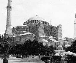 Mosque at St. Sophia, Constantinople
Mosque at St. Sophia, Constantinople
Everyone who visits Constantinople goes to see this great mosque. It is a wonderful example of Byzantine (b -zn´tn) architecture, although its appearance has been greatly changed by supporting walls, and minarets which have been added. St. Sophia, at first a Christian church, was begun in 532 A. D. and was dedicated in 538. Seven years were spent in gathering together the materials for the building. Columns and carvings from pagan shrines in Greece, Syria and Asia Minor were brought to make this the most beautiful church known. The outside does not even suggest the beauty and charm of the interior, which is lavishly decorated with costly marbles, alabaster and porphyry (pôr´f-r). Its walls were inlaid with stones which gleamed like jewels. In 1453, after a long siege, the Turks took Constantinople. Thousands of Christians took refuge in St. Sophia, expecting a miracle to save them. No miracle occurred. The Turks turned the church into a Mohammedan mosque, built the four minarets and destroyed or covered up the symbols of the Christian religion. Every Friday (for Friday is the Mohammedan Sabbath) a priest reads the Koran is St. Sophia, holding a drawn sword in his hand to show that this church was taken from the Christians by force. The Turkish rule has been cruel and destructive. Constantinople, once the center of the government and learning of the world, became one of the most backward of cities. The Turks were allowed to remain in control because no modern nation was ever willing to allow any other to have it. With the defeat of the Central Powers in the World War, these conditions are changed and Constantinople will probably be internationalized. What is the meaning of internationalized? Keystone ID: 10977 Note: All titles, descriptions, and location coordinates are from the original Keystone Slide documentation as supplied by the Keystone View Company. No text has been edited or changed. -
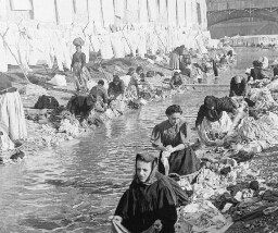 Wash Day, Nice, France
Wash Day, Nice, France
Nice (ns) lies on the Riviera (r-vyâ´ rä) or that part of the Mediterranean (md -tr-´ n-n) between Cannes (kån) and Genoa (jn´ -å). It is a noted winter resort. It is a city of 150,000 population, well situated on a broad bay. It is divided into two sections by a stream. On the one side is the old section of the town. The new part, on the other side, is called the Strangers' Quarter. Here are the homes of the winter comers. The Old Town is of more interest to us than is the fashionable section. Most of the streets are narrow. You would call them alley-ways or narrow lanes. Here dwell the natives of Nice. Here was born the famous Italian patriot, Garibaldi (gä´ r-bäl´ d). The stream that flows through Nice is one of its interesting features. In dry weather it is only a slight creek with a broad stony bed. But it is a treacherous bit of water. It rises in the mountains back of Nice and flows down the slopes to the sea very rapidly. Heavy rainstorms often occur in these mountains. Immediately the creek becomes a torrent. Woe then to the boatman who pays no attention to weather; or worse yet to the dozens of women washing clothes in the creek. The flood sweeps over everything in its path. Many women have thus been drowned. Now there is a watcher who signals a rise in the river. When the danger signal appears, there is a scramble for the upland. You might think this scene an unusual one even for Nice. It is not. You are not visiting here on a Monday! Any week day is a washday in Nice. The peasant women carry their bundles of clothes to the side of the stream, and proceed with the washing. Great clothes lines are set up on the banks, and these lines are usually filled with garments. Keystone ID: 11766 Note: All titles, descriptions, and location coordinates are from the original Keystone Slide documentation as supplied by the Keystone View Company. No text has been edited or changed. -
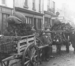 Peat Peddlers, Killarney, Ireland
Peat Peddlers, Killarney, Ireland
Ireland has some coal fields. But by far the most of the Irish use peat for fuel. It is not nearly so good a fuel as coal, but fortunately Ireland has no severely cold weather. In this view you see the little donkey carts piled high with blocks of peat, topped with bags full of peat. It would appear that the donkeys have heavy loads, but peat is very light so that a cartload pulls easily even over the rough Irish roads. The picture here shown was taken in the village of Killarney near the lakes of the same name. Familiar Irish names can be seen on the signs. The Irish carts are usually built after the style of these you see. Both ends have shafts so the donkey can be hitched to either. Ireland has large boglands. It has 1,500,000 acres of swamps. In these the mosses, reeds, and other marsh plants grow rapidly. They die and are covered with water. This goes on year after year till thick layers of vegetable matter is piled up. The Irish drain the swamps, and cut the layers into slices of peat or turf. Cutting peat is an art that nobody knows so well as the Irish. The top of the peat layer has not decayed enough to be real peat. It is sliced off with a spade, and not used. Then is the time to use the peat knife. This is somewhat like our straw or hay knife. It has a long blade and looks like a spade and knife combined. With it a skillful workman can rapidly cut slice after slice of the soft peat from the layer. The cutting is done in the spring, and the pieces are stacked up to dry in the summer. In the fall they are carted into town or to the country houses. Explain how coal is formed. What is the difference between coal and peat? What other substances are used for fuel? Keystone ID: 6110 Note: All titles, descriptions, and location coordinates are from the original Keystone Slide documentation as supplied by the Keystone View Company. No text has been edited or changed. -
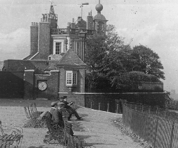 The Regulator of the World's Clocks, Greenwich, England
The Regulator of the World's Clocks, Greenwich, England
You know that latitude is the distance, in degrees, north or south of the Equator. For instance Greenwich is marked 51 degrees north. Any place on the Equator had a latitude of zero degrees; that is, none at all. The poles are 90° north or south as the case may be. Longitude is measured in the same way. But there is no Equator running around the world from north to south. So it had been agreed by the nations that one of the meridians is to be called the Prime Meridian. This meridian has zero longitude. A point 10 degrees east of it is called 10° E.; a point 10 degrees west is called 10° W. What is the longitude of New York? The Prime Meridian runs through Greenwich, England, 5 miles from London. Here is located an observatory. A telescope here is so arranged that exactly at 1 o'clock P. M. every day a big colored ball falls from a tower. The clock which you see sets itself at exactly 1:00 P. M. This time is telegraphed instantly to many parts of the world, and all standard clocks are set by it. It is very necessary that time in all parts of the world be regulated. When it is 1:oo P. M. in Greenwich, England, the clocks 180 degrees distant should show 1 A. M. Why? New York time is 4 hours earlier than London time. Why? Chicago time is 1 hour earlier than New York time. Why? What time is it in London now? Greenwich is on the Thames below London. From the observatory can be seen miles of shipping in the Thames. The great English fleet is frequently assembled near here for review. How many time belts are there in the United States? What time is it now in Calcutta? Keystone ID: 6146 Note: All titles, descriptions, and location coordinates are from the original Keystone Slide documentation as supplied by the Keystone View Company. No text has been edited or changed. -
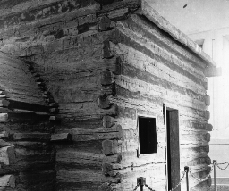 Birthplace of Abraham Lincoln, Hodgensville, Kentucky
Birthplace of Abraham Lincoln, Hodgensville, Kentucky
Here in this cabin was born one of our greatest Presidents. There is but one other who approaches greatness, and that was Washington. The two men were utterly different in almost every way. Washington was born of an aristocratic family and was well educated. On the other hand, Abraham Lincoln came of poor parentage. He had no early education, and he struggled hard to gain the position he finally reached. Unlike Washington, he was always a man of the common people. On September 4, 1916, the spot of ground that is here shown, was set apart "for the people of the United States forever." The Lincoln Farm Association bought this land with the old log cabin on it. They built over the cabin a beautiful Greek temple in order to preserve it. On the date given above, the Association formally presented their gift to the United States. President Wilson, on behalf of the people of the United States, delivered a speech of acceptance. When Lincoln's father settled at this spot there were woods all about. Here the Lincoln family lived until after his mother died. Then they moved to Indiana, and finally Illinois. When a young man he went down the Mississippi on a flat boat and made his first observations on slavery. When he went into politics, the question that stirred him most deeply was that of slavery. He debated against Stephen A. Douglas of Illinois, and gained a national reputation as a statesman. He was nominated by the Republican Party, and was elected in 1861. Then followed the four years of Civil War, the most trying time that a President of the United States ever had. Just as the war was over, he was assassinated. Keystone ID: 16741 Note: All titles, descriptions, and location coordinates are from the original Keystone Slide documentation as supplied by the Keystone View Company. No text has been edited or changed. -
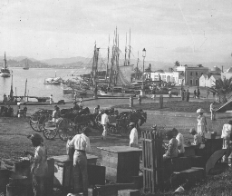 Overlooking the Harbor, San Juan, Porto Rico
Overlooking the Harbor, San Juan, Porto Rico
Porto Rico is about 450 miles east of Cuba. It is fourth in size among the West Indies. It is 100 miles long from east to west, and about 36 miles wide. It would make about three states the size of Rhode Island. Its central portion is mountainous and its coast line is regular. It has, however, an excellent harbor at San Juan (sn hwän´). It is a section of this harbor that is shown in the view. The few buildings shown are typical of the city. You will observe that many of the vessels in the harbor are old-fashioned sailboats. The harbor is being improved so that its entrance will be one-third of a mile wide and 30 feet deep. A large portion of the products of Porto Rico are shipped from San Juan. These products consist of sugar, tobacco, coffee, pineapples, grapefruit, coconuts, textile fibers, vegetables, and phosphate. Most of the trade is carried on with the United States. This trade in 1915 amounted to over $70,000,000. Porto Rico was discovered by Columbus in 1493. Ponce de Leon (pn´ th d l-n´) took possession of the island for Spain in 1510. San Juan soon came to be the leading city. It was attacked frequently by pirates. Sir Francis Drake attacked and plundered the city in 1595. The island remained in possession of Spain until December 10, 1898. Following the Spanish War, it was ceded to the United States. The governor of the island and his executive council made up of 11 men are appointed by the President. The house of delegates is made up of 35 members, elected by the people. About two-fifths of the population are negroes. Locate Porto Rico. On which side of the island is San Juan? Keystone ID: 10252 Note: All titles, descriptions, and location coordinates are from the original Keystone Slide documentation as supplied by the Keystone View Company. No text has been edited or changed. -
 Peeling Bark for Bark Cloth, Uganda, Africa
Peeling Bark for Bark Cloth, Uganda, Africa
Even if you had never heard of Uganda (-gän´ dä) you would know that this scene was in a tropical country. The native is engaged in peeling the bark from a tree with a short-bladed, long-handled knife. He is dressed in clothing which is made from this same kind of bark. This strip of bark will be soaked in water until it is pulpy. Then it is beaten with clubs or mallets until the soft, inner bark comes loose from the rough, outer layer. This inner bark has a texture not unlike that of cloth. It is brown in color, and is used in this form. By piecing it with other strips a garment is made. You will observe that the native you see here has his bark clothes made in the fashion of a gown with an overcoat. His arms are bare, as also are his feet. Uganda is in Central Africa, a little way north of the Equator. It lies west of Lake Victoria and is drained by the headwaters of the Nile. It is as large as the states of Ohio and New York together. Its total population is about 3,000,000, of which number less than 1,000 are white. The territory is ruled by the British. It is largely wooded with tropical forests. It produces rubber, sisal (s´ sl) hemp, coffee, ebony, shellac, gums, sugar cane and castor oil. Its exports consist chiefly of goat skins, hides, coffee, cotton, and cotton-seed. About Lake Victoria a queer disease attacks the inhabitants. This disease is called the "sleeping sickness". The person affected becomes drowsy, goes into a stupor, and dies. The disease has been so widespread on the islands of Lake Victoria that most of the people have fled from them. Find Uganda on a map of Africa. Keystone ID: 17033 Note: All titles, descriptions, and location coordinates are from the original Keystone Slide documentation as supplied by the Keystone View Company. No text has been edited or changed. -
 Lake Nicaragua on Nicaraguan Canal Route
Lake Nicaragua on Nicaraguan Canal Route
Lake Nicaragua (nk´ å-rä´gwå) is the largest body of fresh water in North America south of the Great Lakes. It is 110 miles long, its maximum width is forty-five miles and it covers an area of about three thousand square miles. A large part of the lake, however, is less than fifty feet deep. It is drained by the San Juan (hwän´) River into the Caribbean Sea. Undoubtedly Lake Nicaragua formerly was much higher and drained into the Pacific Ocean, but disturbances, probably volcanic, have uplifted the land and forced it to flow eastward. In the background of the picture may be seen Ometepec (-m´t-pk´) Volcano which stands upon an island of the same name. It is an active volcano. This lake is a part of the so-called Nicaraguan Canal route which would join the Atlantic and Pacific oceans. This route is estimated to be 170 miles long, of which only twenty-eight would need excavation after utilizing Lake Nicaragua and the San Juan River. It was difficult to decide whether this or the Panama route would be better. The Panama route was followed, as the active volcanoes will always be a danger in Nicaragua. But two canals may be desirable when the world recovers from the war. To provide for this the United States Senate in March, 1919, ratified a treaty with Nicaragua by which it is agreed that for a payment of $3,000,000 the United States shall have the right to build a canal and establish a naval base on Point Coseguina (k´s-gw´nä) on the southern shore of Bay of Fonseca (fn-s´kä). Also, the United States is to have the ownership of two islands in the Caribbean Sea. The people are mixed Spanish and Indian. Notice the soldier in the foreground. Keystone ID: 12911 Note: All titles, descriptions, and location coordinates are from the original Keystone Slide documentation as supplied by the Keystone View Company. No text has been edited or changed. -
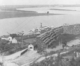 Save and Danube Rivers from Belgrade, Serbia
Save and Danube Rivers from Belgrade, Serbia
Turn to your map of Europe, and locate Belgrade, the capital of Serbia. You will notice that the Save and the Danube Rivers join at Belgrade. The Save River rises in southwestern Austria and flows east. The Danube rises in southern Germany and flows southeast. Trace both rivers on the map. In the view the Save River is the one the steamboat is on. The water flows to your right. The Danube is the curved river. It is flowing toward you. Study the picture carefully. What do you see in the foreground? The view was taken from the heights of Belgrade. In the distance the Austrian city of Semlin can be seen. Belgrade played an important part in the Great War of 1914. From Semlin it was bombarded many times. It was finally captured by the Austrians and Germans. It is a city of about 90,000 people; that is, about the size of Reading, Pa. Nish is the other important city. Serbia is a small mountainous country. It is about the size of Maine. It has a population of about 4,000,000. Its people are very hardy, and are brave fighters. They fought against the Turks in 1912-1913. Then they fought against Bulgaria. In 1915 Bulgaria, Austria, and Germany sent great armies that overran Serbia, and defeated the Serbs. On the farms of Serbia cattle and horses, corn, wheat, and fruits are raised. Copper, coal, and iron are mined. There are not many factories. In the picture what is stacked ready for shipment? Where does the Danube empty? Go by water from Odessa, Russia, to Belgrade. Name the leading nations that fought in the Great European War. Keystone ID: 17300 Note: All titles, descriptions, and location coordinates are from the original Keystone Slide documentation as supplied by the Keystone View Company. No text has been edited or changed. -
 The Way Hiawatha Took Minnehaha Home, Minnesota
The Way Hiawatha Took Minnehaha Home, Minnesota
When Hiawatha had finished asking for the hand of Minnehaha, the Ancient Arrow Maker looked proudly at Hiawatha, then fondly at Laughing Water, and answered: 'Yes, if Minnehaha wishes; Let your heart speak, Minnehaha!' The maiden was standing. She walked over to Hiawatha, and Softly took the seat beside him, While she said, and blushed to say it, 'I will follow you, my husband!' This was Hiawatha's wooing! Thus it was he won the daughter Of the Ancient Arrow Maker, In the land of the Dacotahs! The succeeding part of the description, as Longfellow relates it, has to do with Hiawatha taking his bride home. The marriage ceremony had been simple. The wedding tour was in keeping. From the wigwam he departed, Leading with him Laughing Water; Hand in hand they went together, Through the woodland and the meadow, Left the old man standing lonely At the doorway of his wigwam. Pleasant was the journey homeward, Through interminable forests, Over meadow, over mountain, Over river, hill, and hollow. The way they traveled over river and lake is here shown. It was some such canoe as this that Hiawatha had built by calling to the various trees to lend him their materials. The birch-bark canoe and the upright figures in it call to mind a civilization that has all but gone. Yet it was such scenes as this that were common to most parts of our great country before the coming of the White Man. Savage as was the Indian in war, and lazy as he was, yet he cherished and was true to the wife he had wooed. Keystone ID: 11943 Note: All titles, descriptions, and location coordinates are from the original Keystone Slide documentation as supplied by the Keystone View Company. No text has been edited or changed. -
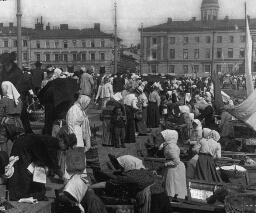 The Fish Market of Finland. Helsingfors, Russia
The Fish Market of Finland. Helsingfors, Russia
Fish are a very valuable food product. People far away from the ocean, lakes, or great rivers in which fish abound do not know how important the fisherman is. Off the Newfoundland coast is a great fishing district. In the waters off the eastern coast of Asia is another. But the greatest fishing grounds in the world are off the coast of Norway. The arms of the Baltic Sea, and the many lakes of Finland are rich in fish. Herring are in the bays, whitefish in the lakes, and salmon in the rivers. In the waters of Finland are caught each year some 20,000 tons of fish; and the chief market of these, in Helsingfors, is here shown. In this market in all kinds of weather, the fishwives stand in their booths and sell their fish. They all wear white head coverings. Down the aisles between the booths go the many buyers. There are Finlanders, Danes, Swedes, Lapps, and Russians among the buyers. If you will look closely you will see almost all kinds of northern Europeans. Observe the different kinds of dress. A fishwife is a woman who sells fish. But she does more. She cleans the fish she sells, and keeps them in good condition. She weighs out to each customer the number of pounds he wishes to buy. In the summer the odor in the market is not pleasant. In the winter, the snow is shoveled away from the booths. To your right you see a row of fishing boats drawn up to the quay (k). In these boats women also stand and offer their fish to the buyers. The second woman from you has just made a sale to the woman who is leaning over the quay. It is hard, hard life these fishwives live, especially in the long, cold winters. Keystone ID: 6652 Note: All titles, descriptions, and location coordinates are from the original Keystone Slide documentation as supplied by the Keystone View Company. No text has been edited or changed. -
 Soldier's Monument and Castle of Chapultepec, City of Mexico
Soldier's Monument and Castle of Chapultepec, City of Mexico
Over 2 miles southwest of the City of Mexico is a lone hill rising 200 feet above the surrounding plateau. This is Chapultepec (chä-pl´ t-pk´). The Aztecs occupied this hill about the middle of the 13th century, 70 years before they began the building of the City of Mexico. Some historians state that the early chiefs of the Aztecs, the Montezumas (mn t-z´ må), used this hill as their residence. We know, at any rate, that they had a burial ground here. In the stones at the foot of the hill are found many of their carvings. Some of these are likenesses of their kings. The Spanish Viceroys who ruled over Mexico saw the possibilities of the hill. It was a good military stronghold, and a pleasant place for a dwelling. They accordingly fortified it and began the building of a palace on its top. This was completed in 1785. It was the residence of these viceroys until the Spanish power in Mexico was broken. Then the palace became the residence of the presidents of Mexico; and this it is to the present day. During our war with Mexico, General Scott, fought his way from Vera Cruz westward towards the City of Mexico. His last battle was the storming of Chapultepec. The castle and its fortifications were bombarded and captured on September 12-13, 1847. The next day the American forces marched into the City of Mexico. The Military College, the West Point of Mexico, is located at the foot of the hill. During the battle with the United States troops, 40 of the cadets of the college took part in the defense of the castle. The monument you see in the foreground was erected to their memory. Keystone ID: 10910 Note: All titles, descriptions, and location coordinates are from the original Keystone Slide documentation as supplied by the Keystone View Company. No text has been edited or changed. -
 Over the Roofs, Damascus, Syria
Over the Roofs, Damascus, Syria
Syria lies northeast of Palestine. You can locate it by noting on your map that part of the country northeast of Arabia north of the Lake of Galilee to the Euphrates (-fr´ tz) River. The chief city of Syria is Damascus. It is on the railroad running south from Aleppo. Its seaport is Beirut (b-rt´) which is 57 miles distant. Its population can only be guessed at. Some guesses place it at 150,000 and others at 235,000.Keystone ID: 7323 Note: All titles, descriptions, and location coordinates are from the original Keystone Slide documentation as supplied by the Keystone View Company. No text has been edited or changed. -
 Market in Jewish Quarter, Warsaw
Market in Jewish Quarter, Warsaw
Warsaw figured heavily in the Great War. It is the railroad center of Poland, then a province of Russia lying next to Germany. Back and forth over Poland the German and the Russian armies fought each other. Much of the province was laid waste. Warsaw was the center both armies tried to get and to hold. You know the result. Russia dropped out of the war because her government fell to pieces. Then Germany was defeated. One of the articles of the treaty of peace made Poland a free country again as she had been a century and a half ago. The Poles set up a new government of their own and elected Paderewski (på´d-rf´sk), the great pianist, as their premier. Warsaw, as in ancient days, is the present Polish capital. Poland is now a nation about three times the size of Indiana with a population one-fifth that of the United States. Its people are chiefly Poles; but in the cities there are very many Jews, as you see. Warsaw has a population of about one million, of which a large number are Hebrews. Many of the Jews are wealthy merchants; but the great majority of them are poor tradesmen. The history of Poland is the story of a hard struggle. About the time of our Revolutionary War, Poland was one of the great powers of Europe. Then came a series of wars with Germany, Austria, and Russia. Poland was defeated and divided among these three nations. For a hundred years the Poles have looked forward to the time when they would again be united and free. In 1919 this came to pass; and again Poland takes her place among the nations of the world. Keystone ID: 20462 Note: All titles, descriptions, and location coordinates are from the original Keystone Slide documentation as supplied by the Keystone View Company. No text has been edited or changed. -
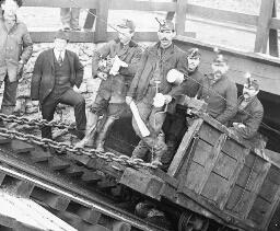 Miners Going into the Slope, Hazelton, Pennsylvania
Miners Going into the Slope, Hazelton, Pennsylvania
You see here a crowd of miners on a car ready to be lowered into a Pennsylvania coal mine. Inside the shaft, running directly down into the earth, there is a tunnel, or slope, as it is. called, leading into the mine. On cars such as the one here shown coal is brought to the surface from far back in the mine. A stationary engine furnishes the power to drag the cars up the steep incline. The scene is rich in suggesting the life of coal miners. On top of the caps of the men are lamps, some of which are already lighted. Oil is burned in these little tin lamps. One of the miners has on rubber boots, because there may be water in certain parts of the mine. Most of the men seen here are foreigners. The overseer or "boss" of the mine is easy to find. If you were to go with these miners you would likely find that the slope was built through a vein of coal. Sometimes, however, the vein is tapped by cutting through dirt and rock. At any rate, when the slope comes to the coal vein, it winds about in the heart of the vein. Leading off from either side of it are long tunnels in which switches have been built so that the cars can be run off to the various rooms and there loaded. The life of these miners is not easy. They are well paid, the amount they receive annually depending on the amount of coal they mine. But it is lonely work. All day long, with drill, pick, and shovel, they labor steadily. Sometimes an accident happens. Gases form in some of the mines, and these are set on fire by the lights on the miners' caps. An explosion occurs. Sometimes many miners are cut off far below ground. Rescue parties may work for days in an attempt to save their lives. Keystone ID: 20049 Note: All titles, descriptions, and location coordinates are from the original Keystone Slide documentation as supplied by the Keystone View Company. No text has been edited or changed. -
 Steel Ingot on the Table of the Blooming Mill, Pittsburgh, P.A.
Steel Ingot on the Table of the Blooming Mill, Pittsburgh, P.A.
After the iron has been melted in the blast furnace and carbon has been driven into it, it is tested to see that it has a certain degree of purity. Then it is dipped into a large ladle or pail, from which it is let into molds. In these it is covered with sand, until it has cooled to a proper temperature. These molds are taken to the blooming mill, where the ingots are lifted out by a large crane and placed upon the blooming table. It is one of these hot ingots that you see lying on the table in the center of the view. Just beyond the table is the blooming machine. The rollers on which the ingot is resting are set into motion, and drive the ingot into one of the five openings which you see in this machine. Here between great rollers, the hot steel is crushed to a smaller size. Then the table is lifted by its own machinery and the ingot is driven between another pair of rollers which make it still smaller. The action is repeated on a still higher plane between another pair of rollers. When the ingot comes from this third process, it has been made into the size desired. Briefly the whole process is that of rolling the hot steel until it is as small as it needs to be. You will observe the streams of water in the mill pouring down on the rolls. This is to keep them from becoming overheated from the ingot. By this method of blooming an ingot can be made into any desired shape. If steel rails are wanted, the block comes out about 6 inches square. It is then called a bloom. It may be rolled thin-only an inch or two in thickness. In that case it may be used as steel plating for vessels and for boilers. Explain what is done in the blooming mill of a steel factory. Keystone ID: 6420 Note: All titles, descriptions, and location coordinates are from the original Keystone Slide documentation as supplied by the Keystone View Company. No text has been edited or changed. -
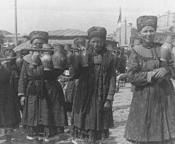 Milk Maids of Kief, Russia
Milk Maids of Kief, Russia
Milk is peddled in many ways throughout the world. In some places in Italy, for example, goats are driven in front of the doors of purchasers and milked in the street. In many cities in South America cows are driven along the streets in the same way, and milked. Milk is condensed and bottled and shipped to far-away places. It is sold in cans and in bottles. But none of these ways is more picturesque than the one here shown. Kief (k´ yf) is in a rich land north of the Black Sea. The country about it produces much grain and many cattle. Milk is plentiful in Kief, and the view shows how it is delivered. Here is a crowd of Russian girls each with a long pole on her shoulder. On these poles are strung small earthenware jars in which the milk is carried. Most of the girls are barefoot, for it is summer time. Each is dressed in the native costume-a one-piece-over-dress, with under-dress and petticoat showing. The girls wear caps of a turban shape. Their faces are bronzed by being out of doors in all sorts of weather. If you want a drink of milk, you can be served here instantly. These girls are not educated, at least not by schools. Education is backward in Russia, but in recent years much has been done toward opening schools. Much of their knowledge of the outside world they get from travelers. Then, too, they attend their church services regularly. They are a simple folk, easily led, yet independent in spirit. Their faith in their religion, their belief in miracles, and their trust in their fellows make the Russians the most striking people in Europe. Compare the appearance of these girls with that of girls in Japan, or in some other country you have seen pictured in the views. Locate Kief. What large port on the Black Sea is near it? Keystone ID: 18103 Note: All titles, descriptions, and location coordinates are from the original Keystone Slide documentation as supplied by the Keystone View Company. No text has been edited or changed. -
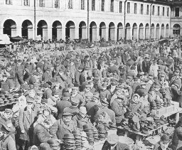
 The Bell Market, Nizhni Novgorod, Russia
The Bell Market, Nizhni Novgorod, Russia
Northeast of Moscow, 240 miles, is the city of Nizhni Novgorod (nyzh´ ny nôv´ g-rt). It is a city of about 100,000 inhabitants, or about the size of Albany, N. Y. Even though it is not so very large, it is known all over Europe and Asia. This is because of its great fair. Fairs are held in many cities of Europe, Asia, and Africa. They are really great markets open for a short time. Russia has more fairs than any other country in Europe. Some 3,000 Russian cities hold fairs every year. The largest and best known of these is held at Nizhni Novgorod. The city is in two parts, divided by the river Oka. On the left bank of the Oka is the "fair city". The ground is laid out in squares with streets crossing at right angles. Many two-story stone buildings have been built to house the goods that are brought here for sale. The fair opens July 15, and closes September 10. During this time a half million visitors come to the city to buy or to sell. All kinds of goods are brought here to be sold. It is said that each year the value of these goods is about $125,000,000. Ships come up the Volga with cotton, rugs, and carpets. Camel trains bring tea from China. Barges carry iron down the streams from the Ural Mountains. The market extends 10 miles up and down the Volga and the Oka rivers. One of the great markets in the fair is the market of bells. Bells are everywhere in Russia. Every city has many places of worship, for the Russians are a religious people. All the places connected with the church have bells. Hundreds of these bells are bought each year at the Nizhni fair in the bell market you see here. Observe the wagon, and the harness of the horse. How are the bells held up? Keystone ID: 6644 Note: All titles, descriptions, and location coordinates are from the original Keystone Slide documentation as supplied by the Keystone View Company. No text has been edited or changed. -
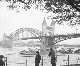 The Rhine Bridge, Bonn, Germany
The Rhine Bridge, Bonn, Germany
The city of Bonn (bn) is on the west bank of the Rhine River 20 miles south of Cologne (k-ln´). The city proper has a population of about 55,000. With its suburbs it contains some 80,000 people. Its chief points of interest to the traveler are its university, its cathedral, its market place, and the great bridge here shown. The Rhine Bridge is one of the most beautiful in Germany. It is built in 3 arches supported by 4 abutments. As you see, the 2 of these in the river are topped by towers connected by an arched building. The towers are decorated with carved figures. One of these figures is a man who has his back turned toward the city of Beuel (bûl) on the opposite side of the river, because the people of Beuel refused to help build the bridge. The central arch of the bridge is 615 feet long. Each of the other arches is 400 feet long, making the entire length of the bridge 1,415 feet. The Rhine at this place is from 10 to 30 feet deep. Until the bridge was built in 1898 ferryboats carried passengers and freight across the river. The University has about 4,000 students and is one of the most famous in Germany. It is one of the favorite places for the education of the nobleman of Prussia. It was founded in 1818. Bonn is the birthplace of the musical composer, Beethoven. Here you see the house in which he was born. In this house are his piano, and other of his musical instruments. Bonn is built on the site of a Roman fortress constructed 10 B. C. For a long while it was the headquarters of several Roman legions. In the Middle Ages it underwent siege after siege. It was at that time a walled city, but the walls were destroyed in 1717. Which way is Bonn from Berlin? Name the most important German cities on the Rhine. Keystone ID: 10339 Note: All titles, descriptions, and location coordinates are from the original Keystone Slide documentation as supplied by the Keystone View Company. No text has been edited or changed. -
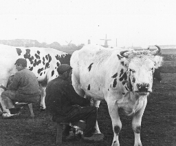 At Milking Time on a Dutch Farm
At Milking Time on a Dutch Farm
The Dutch have never been such noted farmers as their neighbors, the Belgians. They are shrewd traders, stubborn warriors, and bold sailors, as their history fully relates. They hold colonies far over the seas, and they have great cities. The Dutch flag flies in every great harbor of the world at the masts of a Dutch trading vessel. It was the Dutch who were the chief rivals of England for the control of the seas in days gone by. But they have also always been lovers of cattle and of the products of the dairy. The country along the Rhine was settled by the Friesians and Bavarians who brought their herds with them. An early Roman historian tells of their great herds of cattle. The cows you see in the picture came from this same stock of cattle. They are called Holstein-Friesians. You will find plenty of the same breed in the United States. And many kinds of dairy cattle in Europe have come from this stock. The Holsteins are all colored as these cows here. They are white with black spots and patches. They give great quantities of milk, which is not very rich in butter fat. They get their growth early, can stand harsh climates, and are of gentle disposition. There are now in northern Netherlands about 100,000 of these cattle. It is no wonder that the Dutch have a great name as butter and cheese makers. This is a typical Holland scene. The country is so flat you can see almost all of it from a tower in the center. In the background of the view you see the four-armed windmills for which Holland is famed. These mills furnish power to pump water, grind feed, etc. What colonies in America did the Dutch settle? What colonies in the world do they now control? Keystone ID: 12201 Note: All titles, descriptions, and location coordinates are from the original Keystone Slide documentation as supplied by the Keystone View Company. No text has been edited or changed. -
 Greatest Canal Traffic in the World, "soo Canal," Mich.
Greatest Canal Traffic in the World, "soo Canal," Mich.
We hear a great deal of the Suez Canal and of the Panama Canal. But there is a canal in the United States that handles more traffic than either. This is the Sault Ste. Marie or the St. Mary's Falls Ship Canal. It is popularly called the "Soo Canal." More tonnage passes through it yearly than through any canal in the world. This ship canal connects Lake Superior and Lake Huron. You can find it marked and named in your geographies, if you turn to the map of Michigan. The St. Mary's River between the two great lakes is about a mile wide, and falls 20 feet in three-fourths of a mile. To get boats around the rapids a canal had to be built. The Northwest Fur Company built the first one in 1797-1798. Later the state of Michigan took the work up, and finally the Federal Government helped. A ship canal was constructed 1 1/2 miles long, and deep enough to carry the largest lake boats. One of the locks, in this canal is 1,350 feet long and will carry boats that draw 24 1/2 feet of water. The walls and power houses are built of concrete. The entire canal is modernly equipped with electric appliances, as you see. This picture shows how heavy the traffic is that passes through the "Soo." Here are two great lake steamers going through a lock side by side. Boats laden with iron ore from Superior or grain from Duluth or coal from the Pittsburgh district-all pass through this waterway which formerly was only an Indian fishing ground. In 1913 almost 80,000,000 tons went through the canal. The value of this tonnage was about $866,000,000. In 1915 goods to the value of $882,000,000 were transported through the "Soo." Which way is the "Soo" from Detroit? Keystone ID: 16731 Note: All titles, descriptions, and location coordinates are from the original Keystone Slide documentation as supplied by the Keystone View Company. No text has been edited or changed. -
 Tokay Grapes in California Vineyard, Acampo, Calif.
Tokay Grapes in California Vineyard, Acampo, Calif.
Here you are in the greatest grape-producing area in the United States. Note the luxuriant growth of the vines and the fine, big clusters of fruit that hang between each clump. These are the Tokay grapes from which a well-known brand of wine is manufactured. California easily leads all other states of the United States in the production of grapes. In fact it produces nearly as many as all the rest of the states put together. New York ranks second. Its great grape-raising area is called the Chautauqua Belt. This is along Lake Erie, and extends not only through sections of northern New York, but also through northern Pennsylvania and northern Ohio. This westward stretch is really a part of the basin of Lake Ontario which has been filled in naturally. A goodly part of the New York grapes is made into wine but in California the wine varieties and the raisin varieties are about equal. You know that raisins are only sun-dried grapes. California wines are widely known, but since France is the great wine country of the world, most of the California brands are given a French name. Such fine varieties of the wine grape as the Scuppernong and the Catawba are descendants of the wild grapes native to North America. The Tokay variety and many other varieties were imported from Europe. If you turn back the pages of history you will find that the grape is one of the oldest plants cultivated. The Egyptians had their vineyards as did also the Greeks and the Romans. The Romans brought the vine to England, and did much to promote the growth of grapes in France. The first vineyard in this country was set out by a Frenchman in 1610 at Jamestown. Keystone ID: 16747 Note: All titles, descriptions, and location coordinates are from the original Keystone Slide documentation as supplied by the Keystone View Company. No text has been edited or changed. -
 Cocoa Pods on Trees, Dominica, B. W. I.
Cocoa Pods on Trees, Dominica, B. W. I.
Dominica (dm´ -n´ kå) is a small island, one of the Lesser Antilles. It lies between Martinique (mär´ t-nk´) and Guadeloupe (gô´ d-lp´), southeast of Porto Rico. It belongs to a number of islands called the Leeward Group. The island contains only 291 square miles. That is, it is about 1/4 the size of Rhode Island. Its population is about 30,000. The island gets its name from the fact that it was discovered by Columbus on Sunday (Dominica). Like so many others of the islands of this section, it is of volcanic origin. It contains the highest peaks of the Caribbean (kr´ -b´ n) Mountains. One of its peaks is 5,314 feet above sea level. Its valleys are very rich, producing cacao, coffee, cotton, nutmegs, rubber, sugar cane, tropical fruits and sisal (s´ säl) hemp. The island has excellent roads, railroads, and telegraph and telephone systems. The view here shows growing one of the leading products of the island. It is from the fruit of these cacao, cocoa, or chocolate trees that our commercial chocolate is made. The trees are short and stubby, and the fruit grows directly out from the branches on a short stem in the way that cucumbers are attached to their vines. The fruit looks like a small melon or a cucumber. Inside the thick, fleshy covering are the cocoa beans. From 40 to 60 beans lie in each of the pods. Inside the hull of each bean is a light-colored kernel. The hulls are cracked, the beans are taken out, sacked, and shipped in this manner to the cacao or chocolate factory. Chocolate is put up in tins to keep it moist. From it is made an excellent drink, and candies of many kinds. Observe the label on a chocolate tin. Where was the chocolate ground? Keystone ID: 14455 Note: All titles, descriptions, and location coordinates are from the original Keystone Slide documentation as supplied by the Keystone View Company. No text has been edited or changed. -
 Wagon Used to Haul Ammunition to Perry, 1813
Wagon Used to Haul Ammunition to Perry, 1813
Great Britain for a number of years prior to 1812 had been forcing Americans to serve on her ships. This at last led to war. We fared miserably in land battles. The Capitol at Washington was burned by a small British force; and until Jackson's triumph at New Orleans, we had no land victory to compare with Saratoga or Yorktown of the Revolution. But on the water, we proved a match for the "Mistress of the Seas." British commerce was so worried by American vessels that England was at last ready for peace. One of the greatest defeats to the English navy was on Lake Erie. Oliver Hazard Perry and 50 ship carpenters built a fleet of 9 vessels at what is now Erie, Pa. Guns and ammunition had to be hauled overland, for the British fleet controlled the Great Lakes. The covered wagon here pictured was used to haul some of this ammunition. It is of the Conestoga (Con´ es-to´ ga) type, in which settlers used to travel overland to take up new homes. With his new fleet Perry attacked the British fleet on September 10, 1813. During the battle Perry's flagship was so badly damaged, he had to row in a small boat to another of his vessels. Broadside after broadside the Americans sent into their enemies. One British ship after another was disabled, until Captain Barclay hauled down his flag as a token of surrender. You know the famous message Perry then sent to General W. H. Harrison: "We have met the enemy and they are ours: two ships, two brigs, one schooner, and one sloop." Read an account of Perry's Victory on Lake Erie. Why did people travel overland in covered wagon? What were the lines of travel to the West? Keystone ID: 16729 Note: All titles, descriptions, and location coordinates are from the original Keystone Slide documentation as supplied by the Keystone View Company. No text has been edited or changed. -
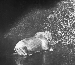 Flashlight of Wild Moose in a Maine Forest
Flashlight of Wild Moose in a Maine Forest
That moose is a queer-looking specimen of the deer family. It is the largest of the deer tribe. The Alaskan variety is the largest kind. These are said to be as much as 8 feet in height, with a spread of antlers amounting to 6 feet. They are ungainly animals on account of the length of the legs, which are out of proportion to the size of the body. Their necks are very short so that they cannot graze. For this reason they live on shrubs and young shoots of trees, such as the willow and the birch. It is because of this that the Indians called them moose. This photograph was taken after night by flash light. The camera hunters were in a canoe in a section of Maine where moose are fairly plentiful. At night moose often come down to a lake to drink and to browse on the lily-pads. They are good swimmers and do not hesitate to swim a cross a good-sized lake. The hunters heard the animal splashing in the water, cut it off from the shore with their canoe, and took the picture as it was clambering in the bushes on the opposite shore. In the winter it is the custom of these animals to live in large families. One male and several females live together in what is called a moose yard in the forest. This they keep open by tramping the snow down. When the moose calves are born they are spotted. If they are taken in time, they can be tamed. In some parts of Sweden and Canada they are used to draw sleds. Keystone ID: 13709 Note: All titles, descriptions, and location coordinates are from the original Keystone Slide documentation as supplied by the Keystone View Company. No text has been edited or changed. -
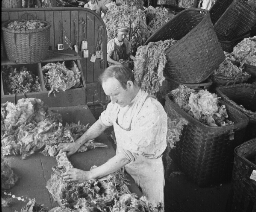 Sorting Wool after Cleaning and Washing, Lawrence, Mass.
Sorting Wool after Cleaning and Washing, Lawrence, Mass.
In pioneer days Grandfather sheared the sheep, and Grandmother sorted the wool and carded it. She then spun her yarn from these on a little spinning wheel that twisted the strands of wool in a smooth long cord. These threads she dyed, and then took great skeins of them to the weaving room. One set of threads she placed lengthwise in the big loom, putting them close together till she had her strip of "cloth" the width she desired. Then she began weaving by running other threads across and over the lengthwise ones. Both sets were beaten tightly together as she went. Thus she made a strip of strong woolen cloth. There is really no difference between the processes of cloth making as grandmother knew them, and those of the present day. In our great factories hundreds of spinning machines fill the bobbins rapidly. Hundreds of looms take the threads so made and weave them into cloth. The work is done faster and evener than Grandma could ever have dreamed of. But the foreman of the factory would tell you that Grandma knew the chief tricks of his trade. Here foe example is the same old process of wool sorting that Grandfather knew something about. The first task is to divide each fleece down the back. The wool from the back and sides of the fleece is put in Grade A basket. Grade B is from the lower parts of the fleece. Grade C is the "rag tag" from the legs; and so on. The man in this picture is busy grading wool. His senses of sight and touch are keenly alive to the values of every part of the fleece. On his judgment depends the final quality of every piece of woolen goods made from material he grades. Keystone ID: 22125 Note: All titles, descriptions, and location coordinates are from the original Keystone Slide documentation as supplied by the Keystone View Company. No text has been edited or changed. -
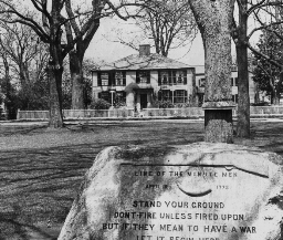 Lexington Common, Lexington, Mass.
Lexington Common, Lexington, Mass.
This is historic ground. Here was fought the first battle of the Revolutionary War. You will recall that the British vessels in the spring of 1775 were lying in Boston Harbor. The Colonists were prepared to resist any attempt of the Redcoats to seize their ammunition. This ammunition was stored at Concord, where it was put for the use of the Minutemen. The British soldiers landed on the night of April 18th. It was on that night that Paul Revere rode out to the towns of Lexington and Concord to arouse the Minutemen so they would be prepared to meet the British. About dawn, on April 19th, on this Common, some 70 or 80 militiamen, commanded by Capt. John Parker, Blocked the way. Captain Parker commanded his men in the woods that are engraved upon this stone. Above these words you see the musket and the powder horn such as were used by the Revolutionary soldiers. The British fired on the Colonists, killed 4 and wounded 9 others. The Americans retreated in the direction of Concord. Scores of trained Minutemen here joined them. It was at the Concord Bridge, not many miles away, that the Colonists again confronted the British. The fire was so hot at this point that the British beat a retreat. The Colonists followed, firing from every house and stone, until the British were chased back to Boston. They had lost 273 men as against 88 of the Minutemen. They did not come out again to destroy military stores, or to arrest Samuel Adams or John Hancock, two Revolutionary leaders who were charged with treason to the King. Read Longfellow's "The Ride of Paul Revere"; Emerson's "The Concord Bridge." Keystone ID: 11680 Note: All titles, descriptions, and location coordinates are from the original Keystone Slide documentation as supplied by the Keystone View Company. No text has been edited or changed. -
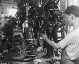 Lasting Machine Shaping Shoes in Shoe Factory, Lynn, Mass.
Lasting Machine Shaping Shoes in Shoe Factory, Lynn, Mass.
All civilized people wear some kind of covering on their feet. Many semi-civilized and savages also have shoes of some sort. You remember that our American Indian made his own deer skin moccasin. And excellent they were, too, for his purpose. They were soft to the feet and silent in the woods. On the other hand, the Hollander wears a wooden shoe. This is cheap, durable, and keeps his feet dry in his wet country. The Japanese wear a sandal so made so that they can slip them off easily when entering the house. It is necessary that they remove their shoes because the rugs on the floor serve at night for the beds. You are reminded of the above facts because we Americans come to look upon shoes as being made of two substances only, either rubber or leather. Where water-proof shoes or boots are needed, rubber is the better. But almost everybody in this country, as in western countries of Europe, wear leather shoes. This leather is tanned from the hides and skins of animals. It is shipped to the factories in bales and rolls, cut to its proper shapes, usually by machines, sewed by machinery, shaped by machinery, and eyeletted and pegged by machinery. In fact the American shoe is largely a machine-made shoe. One of these wonderful machines is here seen in operation. This is the lasting machine, sometimes called the Goodyear Pulling-Over Machine. It is said that it cost $1,500,000 and five years of trial to perfect it. The "upper" of the shoe is placed over the wooden last. The machine is clamped on this "upper" and draws the fore part of the shoe into shape. Thus, in a few seconds, is performed the most difficult task of the shoemaker. Keystone ID: 22189 Note: All titles, descriptions, and location coordinates are from the original Keystone Slide documentation as supplied by the Keystone View Company. No text has been edited or changed. -
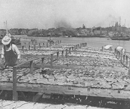 Sun-Drying Codfish, Gloucester, Mass.
Sun-Drying Codfish, Gloucester, Mass.
The city of Gloucester is 27 miles northeast of Boston on the Massachusetts bay, 5 miles southwest of cape Ann. It is an old, old city, the first white people living here in 1623. The first permanent settlement was not made, however, until 10 years later. Just outside its harbor is the Reef of Norman's Woe, celebrated in Longfellow's "The Wreck of the Hesperus." At present Gloucester is a well-known summer resort. It has a population of about 25,000. Its chief industry centers about its fisheries. For a long time Gloucester led every other port in the United States in its annual catch of fish. At present it ranks second, with Boston in first place. In it port are gathered fishing vessels especially fitted for voyages to the fishing grounds in the New England waters and in the waters of the Grand Banks. Cod, halibut, haddock, blue-fish, mackerel, and herring are the principal kinds of fish caught. The view shows how codfish are preserved in the sun. The vessels, usually owned by companies, unload their catch in the store houses on the piers. These houses are fitted up to clean the fish. The heads are chopped off, the entrails taken out, the fish are salted, and put out on platforms to dry. Gloucester Harbor is shown in the middle distance with the city in the background. Codfish sometimes grow to be as much as 5 feet in length. The fish usually caught, however, are very much smaller. They are greenish or olive colored on the back and the sides, mottled with dark spots. They are a good food fish, although bony. During the spawning season which is from November to April, they approach the coast in schools. This is the fishing season for the men of Gloucester. Keystone ID: 20221 Note: All titles, descriptions, and location coordinates are from the original Keystone Slide documentation as supplied by the Keystone View Company. No text has been edited or changed. -
 Spinning Cotton Yarn, Lawrence, Mass.
Spinning Cotton Yarn, Lawrence, Mass.
When one looks at a view of this sort, he is confused by the great number of machines. His first thought is that cloth making is too difficult for him to understand. But really there are just two main processes to hold in mind. The first of these is the spinning of the thread by twisting together a number of fibers. The second is the weaving; that is, lacing together two sets of cross threads. Our modern cotton mills weave cloth on a large scale. Most of the work is done by machines which are watched over by careful experts. The first thing done is to examine the cotton in the bale for its quality and its length. It is necessary that the fibers used in a certain grade of cloth be of certain fineness. The machines, too, are set to handle fibers of a certain length. Hence the sorting of the cotton is a very important item. The selected bales are then opened, the cotton is cleaned, and carded. The carding machine combs out the fibers, and makes them lie in parallel rows. These strands are put into cans, and is called sliver (long "i"). The sliver is next "drawn"; that is, 6 strands are drawn through 3 sets of machines until they lie straight and close side by side. The threads pass next into roving frames which make them the desired size. From the roving room the thread is taken into the spinning room. It is this room you see in the view. In these mills more than 330,000 spindles are busy twisting the threads into yarn. It is this yarn that is woven into cloth. The girl watches for broken threads, or empty bobbins. Locate Lawrence on your map. Why are so many of our cotton mills in New England? Why are they not all in the South where cotton is grown? Keystone ID: 22080 Note: All titles, descriptions, and location coordinates are from the original Keystone Slide documentation as supplied by the Keystone View Company. No text has been edited or changed. -
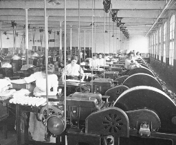 Straightening Silk Fibers, South Manchester, Conn.
Straightening Silk Fibers, South Manchester, Conn.
A great deal of raw silk we get does not come to us in skeins. It comes in bales made up of cocoons, the threads of which have been broken, and of loose threads. The cocoons have to be boiled in soapy water to do away with the gum that holds the tiny threads together. They are then dried in drums which are curiously made. The inner portion of these drums is full of holes. As the drums turn rapidly the water is thrown out through the tiny screens. In this way the silk fiber is freed from water. These washed cocoons pass then to the dressing mill where they are ripped open by rollers set full of sharp needles. The silk fibers are thus pulled apart in great sheets called laps. The laps are then run through a picking machine. This machine draws the threads out still more and cuts the laps into short lengths. Then follows more cleaning and drawing, until the laps are put together into longer laps from 7 to 9 feet in length. These are then ready for spinning. It is a series of picking or drawing machines that you see here. The machines are arranged in rows, or batteries as they are called. Each machine has a number of plates of needles, which act as combs. The fibers come from the combs straightened. They then wrap about the drums to the right. From these they are removed and rolled in small laps. The laps of silk can be seen on the little tables by which the women are standing. You will note that the whole room is filled with machines, all of which are busy with the process of "first drawing" the silk. The building appears to extend to an endless distance. You will be interested to know that this is the largest silk factory in the world. Keystone ID: 20312 Note: All titles, descriptions, and location coordinates are from the original Keystone Slide documentation as supplied by the Keystone View Company. No text has been edited or changed. -
 Chiseling Marble, Proctor, V.T.
Chiseling Marble, Proctor, V.T.
Marble is taken from the quarry in great slabs or blocks. These are broken loose from the layers, lifted on cars by electric cranes, and brought to the bottom of the quarry shaft. They are then lifted to the surface by big derricks, placed on other cars, and taken to the sawing mills. At these mills, great bands of steel lying side by side move back and forth on top of the slabs. Water pours down over the saws and rocks so as to keep the stone moist. Sand is also poured into the grooves. The bars have heavy weights on them, so that their constant moving back and forth, by the help of the sand, gradually wears a narrow path through the stone. It is slow business, but it is a great saving in time and in stone over the older processes of hand chiseling the blocks to pieces. After the stones have been sawed to the thickness required, they are sent from the mills to the departments for which they have been made. The scene here shows a corner of the architectural department. That is, the stones seen here are to be used for building purposes. Here they are finished off. This finishing may consist only in the smoothing up of the stone to the proper size. It more often means that the blocks are to be carved in beautiful designs. This is done, as you see, by a compressed-air chisel operated by skilled workmen. The one nearest you is finishing a beautiful Greek design. This stone is likely to be used at the base or at the top of a great pillar. The compressed-air chisel is a big step in advance over the old-fashioned hand chisel which is driven by a mallet. The hand mallets are still used in finishing up some of the nicer work. You see some of these mallets and chisels lying about in this room. Keystone ID: 13706 Note: All titles, descriptions, and location coordinates are from the original Keystone Slide documentation as supplied by the Keystone View Company. No text has been edited or changed. -
 Workmen Cutting Leather for Shoes, Lynn, Mass.
Workmen Cutting Leather for Shoes, Lynn, Mass.
Formerly each farmer tanned his own hides, or there was a small tannery in the neighborhood which brought up the skins and did the tanning for a locality. Each year a shoemaker made the rounds of all the homes in a community, and made shoes or boots for every member of the family. In doing this, he would his wooden last for the largest foot in the household. When the boots or shoes had been fashioned for the first pair, he would trim down the last to the next largest in size; and so on until the family was supplied down to the smallest child. A bit later, each community had it shoemaker's shop. This shoemaker bought his leather form the tannery and made boots and shoes for the people of the neighborhood, who came to his place to have their feet measured. Now the entire industry is changed. We go to a store, select our pair of shoes, and our part of the business is done. But this is the smallest and the easiest part. Such factories as this great one shown here are busy turning out shoes. The total value of boots and shoes manufactured in the United States, according to the 1910 census, amounted to almost $700,000,000. Massachusetts takes first rank in this industry. To the boot and shoe factories comes leather from Russia, South America, Texas, France, Germany, England, and even far away China and Korea. These workman in the view are cutting leather. One man cuts out only certain parts. You can tell this by the product the first workman on the right is turning out. All his pieces are the same shape. The shoes on which these men are working are extra fine. Usually the cutting is done by machines. The United States is the home of the machine-made boot and shoe. Keystone ID: 22188 Note: All titles, descriptions, and location coordinates are from the original Keystone Slide documentation as supplied by the Keystone View Company. No text has been edited or changed. -
 Making Paper from Rags, Holyoke, Mass.
Making Paper from Rags, Holyoke, Mass.
Paper is made from many kinds of vegetable fibers. Wheat straw is used in making coarse strawboard. Rice straw is used largely in Japan for the making of paper, but the most of the cheaper grades of paper are made from wood pulp; that is, wood shredded into fine pieces. Our finest grade of paper commonly used is made of rags. This view shows you one of the processes of making paper from rags in one of the biggest paper mills in our country. You have all seen the ragman driving about gathering up sacks of cast-off clothing, or even picking up bits of cloth. These rags are bought by the pound by the pickers, and sold by them by the pound. They are shipped to the large rag paper mills, a large number of which, in this country are in Massachusetts and Connecticut. After the rags have been sorted, so as to grade them according to fineness of fiber, they are washed and cut into pieces. The view shows you great boxes of cut rags, just as they have come from the drums in which they have been washed. After many processes, including grindings and rollings, these rags turned into the fine linen paper that you use for stationery. The state of Massachusetts ranks second in the paper-making industry in this country. It easily leads all other states in the making of rag paper. This industry centers in the Connecticut and Berkshire Valleys. The city of Holyoke is easily the center of the paper-making industry in the United States. Every day some 300 tons of fine paper are produced in the mills. Notwithstanding this output, the United States imports a great deal of its paper of fine quality. Germany leads in the manufacture of rag paper. Keystone ID: 22068 Note: All titles, descriptions, and location coordinates are from the original Keystone Slide documentation as supplied by the Keystone View Company. No text has been edited or changed. -
 Skilled Workers Manufacturing Jewelry, Providence, R.I.
Skilled Workers Manufacturing Jewelry, Providence, R.I.
Most people decorate themselves with some form of jewelry. It may be a tie pin, cuff links, brooch, fancy hairpin or hat pin, a breastpin, a ring or bracelet,-or what not? This is true the world round. Some wise man said that the more nearly one approached the savage state, the more jewelry he wore. It is likely that this man, somewhere about his clothing, found use for a piece of jewelry. It is true, however, that savages are especially fond of ornaments. You recall that the American Indians were especially fond of beads. The Central African believes in wearing a large copper or brass ring in his nose. Other tribes of savages pierce the lips with some kind of bar or pin which supports a ring or spangle. Finger rings are worn by peoples in all states of civilization. In our country the making of jewelry has become centered in southern New England, particularly in Rhode Island. This is due to the fact that the work in this industry is done mostly by hand. It follows then that it must be carried on where the population is dense. New England has this large city population and it has also the other facilities needed for factories,such as railroads and water power. Here you are shown how jewelry is made in one of the factories in Providence, R.I. Skill, care, and patience are all required of these busy workers. You will observe on the tables the tools of trade. Gas jets are needed to heat the metals, and bowls of water for rapid cooling. Here, too, are hammers, forceps, saws, tweezers,-all the finer tools that you see in any jewelry store in your home town. Providence is the largest center of jewelry manufacture in the United States. Keystone ID: 16773 Note: All titles, descriptions, and location coordinates are from the original Keystone Slide documentation as supplied by the Keystone View Company. No text has been edited or changed. -
 Copying Design to be Printed on Cotton Coth, Lawrence
Copying Design to be Printed on Cotton Coth, Lawrence
After the cotton fibers are twisted into threads called yarn, this yarn is out into great looms and woven into cloth. The process of weaving consists in criss-crossing, in regular fashion, two layers of threads running in opposite directions. After the cloth is woven there is still much to do before it is marketable. From this point on, the various processes are referred to as finishing and printing. When the cloth comes from the looms it is a brownish gray. It must first be singed to make it smooth and bleached to make it pure white. It is singed and bleached in strips. In the mills here pictured, pieces of gray cloth are sewn together till they make a strip about 40,000 yards long. That is, 23 miles of cloth move over gas flames which burn off the fuzz. This is a delicate process, for if the flame is a bit too high, or the seed of the cloth too slow, the strip will catch fire. The strip of cloth next passes into bleaching vats where it is boiled in chemicals which make it pure white. This cloth is now ready for market as white cloth. But much of the demand is for colored or patterned goods. The patterns are printed on the white cloth by copper rolls, much after the fashion of paper printing on roller presses. To get the design on the rolls is the next step. This is the making and the transferring of the design. Skilled artists draft suitable designs. These are photographed, engraved on zinc, and transferred to copper rollers by a chemical process. Each color demands a separate plate. The girl in the view is busy painting on the engraved zinc plate, those parts of the pattern which belong to one color. Making ready the copper rolls for printing is one of the most interesting processes of clothmanufacture. Keystone ID: 22082 Note: All titles, descriptions, and location coordinates are from the original Keystone Slide documentation as supplied by the Keystone View Company. No text has been edited or changed. -
 View of Printing Room, Cotton Mills, Lawrence, Mass.
View of Printing Room, Cotton Mills, Lawrence, Mass.
The gray cotton cloth that comes from the loom is singed over a gas flame to make it smooth. It is then bleached to make it white. The next process is coloring or designing it. Special artists paint attractive designs which are copied on zinc plates and transferred to copper rollers. Only that part of the design that is in one color is out on a roller. Enough rollers are needed to cover all colors the design calls for. These rollers are supplied with the proper colored inks. As they revolve they print the white cloth as it speeds under them. Great care must be taken to see that all colors are properly registered. That is, that part of the design on each copper plate must fall exactly where it belongs or the colors will overlap. The view shows the enormous extent of one of these printing rooms. You will observe the printed cloth coming over. A foreman is here seen inspecting a bit of the print. After it is printed the cloth is run over large copper cylinders filled with steam. The steam dries the inks. The cloth is next folded down in great piles. It is then soaped and washed to make it clean. Again it is drawn over steam cylinders to dry it. It is then starched and stretched and dried-all by special machines. Then comes the calendering, or ironing, if the cloth is to be smoothly finished. If the cloth is not to be smooth, it is run through a napping machine which scratches the surface till it is fuzzy. After the goods have been ironed or napped it is folded, measured, and put on bolts containing 35 or 40 yards of cloth. The factory you have seen in this view finishes about 5,000,000 yards each week. This means that enough cloth of different widths is here made in a year to reach around the world 6 times. Keystone ID: 22083 Note: All titles, descriptions, and location coordinates are from the original Keystone Slide documentation as supplied by the Keystone View Company. No text has been edited or changed. -
 Inspecting Paper, Holyoke, Mass.
Inspecting Paper, Holyoke, Mass.
Paper making machines are large affairs. Sometimes they weigh as much as 400 tons each. But they handle each sheet as carefully as if they had fine sense of touch. These machines take the stock, press it into paper, fold this paper, and cut it into the desired size of sheet. You see here a battery of paper machines performing the last act in paper manufacture. The finger bars, made of flat strips of wood, receive the cut paper, and turn the sheets out on a receiving table. At this table stands an inspector. She is an expert in her work. Each sheet of paper undergoes her careful scrutiny. If it is defective in any way the sheet is thrown out; for nothing but first-class material is produced in this factory. Sometimes a sheet will have a flaw in coloring, or in texture; or it may have been torn slightly in its many handlings. The sheets that are approved are stacked up, and are ready for further folding or cutting if needs be. You will observe certain things in this factory that are necessary both for health of the workers and for the work. The place is well lighted by side windows. The inspectors do not have to face a bright glare. Nor do they have to work under artificial light. They are seated, so do not tire so quickly at their exacting wok. The machines have iron guards to reduce danger of accidents. All this is very much in contrast with the factory of several years ago, when employees were looked upon merely as a part of the machinery. Of what things is paper made? Name some of the processes in paper making? How does our supply of paper depend on forests? Account for the shortage of paper during the Great European War. From what is pulp made? Keystone ID: 22070 Note: All titles, descriptions, and location coordinates are from the original Keystone Slide documentation as supplied by the Keystone View Company. No text has been edited or changed.
Showing 1-50 of 404 records.