Records
Your search returned 543 Results
- Iconographic browsing
- Results per page : 10
-
Emptying Pig Iron from Molds into Car, Pittsburgh, P.A.
In view No. 63 you saw the pig iron machine at rest. You viewed it from the end at which the blast furnace stands. You were looking toward the freight cars on the switches in the distance. In these cars, you will recall, the pigs are dropped. This view shows you the opposite end of the pig iron machine. Directly in the foreground and below the machine is the freight car. The first thing you will observe are the great cog gears that turn the spindles about which the pig iron belt revolves. You will observe the heavy steel chain that holds the cast iron boxes in place and yet allows them to revolve about the wheel. This chain is made of links composed of two strips of steel, one on either side of an iron spool. These little spools fit into the cogs on the spindle, and the two steel bars connecting them fit nicely over each cog. You also have here a very distinct view of the cast iron pigs. The three molds at the top of the spindle contain pig iron. Those below have dropped their bars into the car. Most of the pigs fall out of the troughs of their own weight. Occasionally one sticks fast so that it must be tapped to release it. The big hammer, the end of which you see, is to loose these occasional pigs. The entire pig iron belt is about 200 feet long. That is, the car is about 100 feet from the blast furnace. The belt moves very slowly, but not slowly enough to allow the pigs to cool thoroughly by the time they reach the car. Hence water is sprinkled over them by automatic (ô´ t-mt´ k) sprinklers as they pass along. Imagine yourself the man standing in this car. Give a brief talk explaining your duties. Keystone ID: 6531 Note: All titles, descriptions, and location coordinates are from the original Keystone Slide documentation as supplied by the Keystone View Company. No text has been edited or changed. -
Line of Sand Dunes, Columbia River, Oregon
On your right in the view flows the Columbia River. On the river bank is a railroad track. To the left of the track is a slender barrier made of boards. This barrier has been built to prevent the sand from burying the railroad tracks. The dunes are low and hills stretching straight ahead of you in the center of the view. The sand is blowing so violently that the foreground of the scene looks like a heavy dust cloud; and it is flying with such force that the man is protecting his face with his hat. Sand dunes are formed like snowdrifts. Perhaps you have seen the wind pick up the snow in great swirls and pile it in drifts along fences. You have seen dust clouds carried by a gale. If you put in the place of the snow or the dust a great stretch of sand, you would have a sand storm, and a sand dune would be formed. In some parts of the world these dunes are from 200 to 300 feet high. But they are usually only from 10 to 20 feet. The dunes usually start about the stump of a tree, a house, or anything solid. Once it is started, the sand continues to gather until a ridge is built. There is a natural limit to its height. The upper wind is stronger than the wind next to the earth, so that after a dune has reached a certain height. The upper wind is stronger than the wind next to the earth, so that after a dune has reached a certain height the wind tears its top off and carries the sand beyond. In many places forests have been the barriers. The dunes may kill the first line of trees; then shift farther into the forest until a great wooded area has been deadened. In some places the dunes have marched over great areas of land that has been tilled, making it useless. On the shores of the Baltic Sea towns have been wiped out by the march of the dunes. Explain how sand dunes are formed. Keystone ID: 6228 Note: All titles, descriptions, and location coordinates are from the original Keystone Slide documentation as supplied by the Keystone View Company. No text has been edited or changed. -
Great Ocean Liners at the Docks, Hoboken, N.J.
When a traveler comes into New York harbor his attention is claimed by a number of things. Undoubtedly the first point of interest is the high buildings of Lower Manhattan. Then he turns for a look at the Statue of Liberty and Ellis Island. As he goes farther northward towards North River (the lower course of the Hudson), he sees an equally wonderful sight. It is the shipping on the Jersey and Manhattan shores of the North River. On the southwest shore of New York Bay lies Bayonne, N.J. Jersey City is on the west shore of North River opposite Lower Manhattan. Hoboken lies just north of Jersey City-with no real dividing line between the two cities. In effect there is one great city from Bayonne for 15 miles north on the west bank of the Hudson. These cities are admirably located for steamship traffic. They have New York harbor on front of them and a great railroad connection back of them. Most of the railroads leading into the City of New York end on the west shore of the Hudson. Hoboken has a population of 67,611 (1915). It is the most densely populated city in New Jersey. It is the terminal of the Delaware, Lackawanna and Western Railroad; and Jersey City just below it is the terminal of the Erie and the Jersey Central and the freight lines of the Pennsylvania. The steamship lines whose boats put in at its piers are the Hamburg-American, North German Lloyd, Netherlands-American, and Thingvalla. These large vessels are German liners which took refuge in this harbor when the Great European War broke out in 1914. They stayed at their piers to avoid being captured. Keystone ID: 16762 Note: All titles, descriptions, and location coordinates are from the original Keystone Slide documentation as supplied by the Keystone View Company. No text has been edited or changed. -
Niagara Falls in Winter, Niagara, New York
Most people see the Niagara Falls during the summer. This is because most of us take our vacations during the summer months. The falls are worth seeing any season of the year; but they are most wonderful in the winter. You are here looking from Luna Island toward the American falls. A large part of the surface where the water is shallowest is covered with a sheet of ice and snow. The heavier parts of the falls are almost free from the touch of winter. At our backs are the Canadian falls which carry nine times as much water as do the American falls. At the end of the bridge is a tunnel which leads to the big electric power plant a quarter of a mile down stream. In this power plant are installed the great turbine generators which produce almost a half million horse power of electrical energy. This electricity runs the street cars of Buffalo, Syracuse, and other cities in New York, and is transmitted to Cleveland. Father Hennepin was the first white man to see Niagara Falls. He discovered it in 1678. LaSalle built a fort here in 1679. During the war of 1812 many battles were fought about Niagara. The state of New York has reserved 107 acres as a park on the American side of the Falls. Canada has a larger reservation on the Ontario side. On the banks of Niagara Falls is located the city of Niagara Falls. This city has a population of about 43,000 (1915). It is 16 miles north-northwest of Buffalo. Niagara falls has become a great center for manufacture of wood pulp, paper, chemicals, and prepared foods. Several trunk lines of railway cross the Niagara River at this point. The electric power furnished by the Falls adds greatly to its importance. Keystone ID: 171 Note: All titles, descriptions, and location coordinates are from the original Keystone Slide documentation as supplied by the Keystone View Company. No text has been edited or changed. -
Drying and Shipping Nitrate, Chile
Nitrate is an important chemical fertilizer. It is used to build up poor soils from which crops have largely taken the nitrogen. It is also the principal chemical used in making gunpowder and other explosives. The importance of nitrate during the Great War cannot be too much emphasized. It furnishes powder for the armies, but it also is drawn upon heavily to grow the crops to feed the armies. By far the greatest nitrate fields in the world are in Chile. The nitrate country is almost a desert. Water is rare, and in many cases is piped from the Andes, a hundred or more miles distant. Each refinery is a little mining village. There are more than 150 such "plants," most of which are owned by Englishmen. On the eastern border of Chile are the Andes Mountains. Many miles west of these is a coastal range. Between the two is a valley. In the northern part of this valley are great nitrate and salt beds. These beds are found for 150 miles from north to south. The raw nitrate generally lies very near the surface. Usually it is covered by only a few inches of sand and rock; but sometimes it is several feet below the surface. The layers of sand and rock are blasted loose. Then the "nitrate rock" is broken loose with crowbars and loaded in large chunks on carts or tram-cars. At the refineries it is boiled in a series of large containers. (Much of our iodine is a by-product of nitrate refining.) The nitrate collects on top of the water. The surface coating becomes thicker in each successive tank. Finally it is drawn off, dried, and sacked. Then it is loaded on freight cars and taken to a Pacific seaport and shipped to Europe or America. Iquique (-k´ ka) is the chief nitrate port. Keystone ID: 22369 Note: All titles, descriptions, and location coordinates are from the original Keystone Slide documentation as supplied by the Keystone View Company. No text has been edited or changed. -
View of Stockholm, Sweden
Before you is a bird's-eye view of the capital of Sweden. A part of the water front of the city is to your right. And what looks like the street is more nearly a bridge; for there is water to the extreme left also. All about the city are waterways. For this reason Stockholm is called the "Venice of the North." But the Venice of Italy is built on piles. Stockholm is set upon natural granite. Water and stone abound in Sweden. One acre out of every twelve in the whole country is water, and the granite breaks out in its highlands. Stockholm is an important seaport on the Baltic. Like many other Baltic ports its waters are frozen in winter; but many flags fly in its harbor in the shipping season. The city is the seat of government and an educational center for the country. It has many factories, cotton and linen mills, iron foundries, and sugar refineries. It is about the size of New Orleans. Do you know what we get from Sweden? Its forest supply matches, woodenware, and paper, and its mines furnish high-grade iron. The Swedes are a thrifty, hard-working people. They raise many cattle and sheep, and make butter and cheese. Potatoes, rye, sugar beets, and oats are grown on the small farms. Stockholm is an old city. Its history can be traced for more than 700 years. Out of the gates of its ancient castles marched many armies to battle against the Germans, the Danes, or the Russians. Under two of its kings, Sweden was one of the chief powers of northern Europe. Then Stockholm was the queen city of the Baltic. Keystone ID: 13000 Note: All titles, descriptions, and location coordinates are from the original Keystone Slide documentation as supplied by the Keystone View Company. No text has been edited or changed. -
Tractor at Work Near Lima, Peru
In the southern portions of Peru in the rich valleys farming is carried on extensively. The most common crop, because it is the most profitable, is sugar cane. This cane is grown on large plantations, called haciendas (hä´ s-n´ dä). These are owned chiefly by rich landholders, but sometimes by companies of men. The natives do the labor at so much a day. You will note that modern machinery is used to make the soil ready for planting. Here is a tractor hitched to a narrow and a pulverizer. You will observe that the harrow is fastened between the two sets of wheels. The revolving pulverizer or steel roller is attached behind the second pair of wheels. This tractor is made somewhat differently from the ones commonly used in our fields. This does not have its own power. The power is furnished by an engine at the end of the field, which draws the machinery back and forth by means of a cable. You can see the large disk upon which the cable winds. The engine is located directly ahead of the tractor at the other side of the field. Cane was brought into Peru by the Spaniards. It was formerly tended in an old-fashioned manner by hand. Now most of the sugar estates are fitted up with modern machines similar to the one you see here. More then that, most of the haciendas have little railroads upon which the harvested cane is loaded and hauled to the crusher. There the sap is crushed from the stalks and is boiled down into the form of raw sugar. The annual production of sugar in Peru amounts to more than 175,000 tons. This large amount is grown on a small percentage of the soil that is fitted for sugar production. The soil is so rich that the cane is cut several times every year. Keystone ID: 21869 Note: All titles, descriptions, and location coordinates are from the original Keystone Slide documentation as supplied by the Keystone View Company. No text has been edited or changed. -
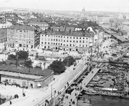
Market Scene, Cologne, Germany
Cologne (k-ln´) is the largest German city on the Rhine, and the chief German port on this river. It has a population of over 500,000. It is a first-class manufacturing center, and one of the strongly fortified cities of the empire. A garrison of about 8,000 men is stationed here all the time. The city gets its name from the Latin word "Colonia", given it by the Romans, because it was a military colony or center, formed by the wife of the Roman emperor, Claudius, in 50 A. D. It soon was made the capital of the Roman province called Lower Germany. During the 13th, 14th, and 15th centuries it was one of the most powerful cities in all Europe. It was a great cloth-weaving center, and carried on heavy trade with neighboring cities and countries, particularly with London. Its commerce of to-day is so important that 5 1/2 miles of wharves have been built along the banks of the Rhine. Across the river there is a bridge of boats. It is made of barges, lying side by side, with boards covering them. Sections of the bridge move out of the way to permit the passage of river boats. The city has important machine shops, and manufactures woolen and cotton goods, carpets, cigars, tobacco, chocolate, candles, soap, and perfumery. The perfumery is named after the city-cologne. The chief single point of interest is the great cathedral. This was begun in 1248, and finished in 1883. It is one of the finest specimens of Gothic building in Europe. It is 570 feet long, 200 feet wide, and the towers are 515 feet high. The market scene here shown is chiefly of interest because of the large number of women. The German women do their own gardening, carry the produce to market, and sell it. For what is Cologne noted? Keystone ID: 2002 Note: All titles, descriptions, and location coordinates are from the original Keystone Slide documentation as supplied by the Keystone View Company. No text has been edited or changed. -
Feeding Hereford Cattle, Manhattan, Kansas
This is a fine herd of Herefords. They are all thoroughbreds that are being made ready for market. These cattle get their name from the county of Herefordshire, in England. Here the breed had its beginning. Herefords came from a stock that had long been used for pulling heavy loads. Hence, they have heavy necks and shoulders, and thickset legs. Henry Clay, of Kentucky, brought the first Herefords into America. For the last 40 years they have been a popular breed among the farmers and cattle raisers of the Middle West. This breed of cattle takes on flesh readily, they are hardy, and their flesh is of fine flavor. They are a good beef cattle. Shorthorns are the heaviest of the beef breeds. Herefords rank next in weight. Stockmen have found that it is more profitable to feed beef cattle for the market while they are young and growing. Corn is the principal food used in the feeding of cattle that are being prepared for market. Many cattle ranches and cattle ranges are found throughout Kansas, Nebraska, and the Dakotas, and also on the plains of Oklahoma and Texas. The corn belt extends from Ohio, through Indiana, Illinois, Iowa, and Missouri, to central Kansas and Nebraska. It follows naturally that the corn belt should also be the center of the stock-raising industry. Much alfalfa is grown in these states, and this is also an important factor in stock feeding. The long, narrow troughs from which the cattle are feeding, are filled at regular periods with corn, oil-meal, and other fattening foods, and the cattle come to their meals as regularly as we go to ours. The large shed in the background contains alfalfa. This the cattle may eat at any time they wish. Keystone ID: 16710 Note: All titles, descriptions, and location coordinates are from the original Keystone Slide documentation as supplied by the Keystone View Company. No text has been edited or changed. -
Sponge Market, Key West Harbor, Florida
The "sponges" that are sold are only skeletons. Sponges are animals that attach themselves to rocks on the bottoms of warm seas. The openings in the sponge which you buy are, in the live sponge, filled with soft jelly-like matter. This soft substance can be readily squeezed out. Divers collect the sponges from rocks, with long rakes or hooks. These sponges are put into boats, carried to the shore, and there left until the jelly-like matter decays. Then they are washed, dried, sorted, and shipped to market. It is one of these markets at Key west that is here seen. You will observe that the sponges shown are round in shape. This is because their long ends have been trimmed off. Many of the finer varieties are bleached before marketing. Sponges are found in many parts of the world in warm seas. But there are only a few places where sponge fishing is profitable. The best known of these are along the eastern shores of the Adriatic Sea, and off the coast of Greece and Asia Minor and parts of Africa. In the Western Hemisphere the chief sponge fisheries are off the Florida coast and among the Bahama Islands. Key West is a city of 20,000 inhabitants on the most westerly of the Florida Keys, or islands, in the Gulf of Mexico. Its chief industries are the manufacture of cigars, fancy shellwork, and sponge factories. The city has a great harbor which the government has fortified. Key West is a well-known winter resort. Its most interesting feature is the railroad which leads from the island to the mainland of Florida. This road bridges great stretches of the open gulf, and is the only railroad that is largely built over the waters of the ocean. Keystone ID: 9175 Note: All titles, descriptions, and location coordinates are from the original Keystone Slide documentation as supplied by the Keystone View Company. No text has been edited or changed.
Showing 1-10 of 543 records.