Records
Your search returned 543 Results
Refined by : tiff scanned file from original glass slide
- Iconographic browsing
- Results per page : 50
-
Zinc and Lead Mines, Joplin, M.O.
Joplin, Missouri, is the center of our zinc and lead production. In 1915 the United States produced over 460,000 tons of crude zinc, valued at $45,000,000. In the same year our mines produced 500,000 tons of lead, valued at $40,000,000. Missouri leads all other states in the production of both minerals. Zinc is not mined as a free substance. That is, it is found combined with other elements such as sulphides, carbonates, oxides, etc. By carefully worked out processes of heating, zinc is reduced from these compounds. The metal is much usedas an alloy with copper to produce brass. It is also used for roofing, and for coating or galvanizing iron to prevent rusting. The United States is the largest zinc producer in the world. Lead, like zinc, is obtained from a compound. The chief ore from which lead comes is the sulphide which is mined is grayish, shiny cubes. There are a number of processes of securing the lead from the ore; but heat is the chief factor in each. Afterwards the crude lead is refined by still more heating. Lead is a very valuable mineral. It is used largely in making bullets and shot. Air and water have little effect on it so it is used for piping, roofing, and lining of tanks. The view shows a shaft house that sets over the entrance to a zinc and lead mine. In this house is the machinery that runs the shaft elevator to bring men and minerals from the mine. The smelter you also can see on the right. Here the mined ores are refined into the crude metals. The pile in the background is called the tailing pile. It is made up of the tailings or left-over minerals from which the metals have been taken. Locate Joplin. What mountains are in southern Missouri? Keystone ID: 16704 Note: All titles, descriptions, and location coordinates are from the original Keystone Slide documentation as supplied by the Keystone View Company. No text has been edited or changed. -
Zeppelin Flying Over a German Town
The only lighter-than-air machines that have been made that can be directed and controlled are the dirigibles (dr´-j-b'ls). Count Ferdinand von Zeppelin (zp´-ln), a German, spent much of his life trying to make the dirigible a success. Largely due to his work, Germany stood first in the development of dirigibles for many years. In fact, his name was commonly given to these German machines. For a number of years Germany had regular carrying routes for the Zeppelin. Passengers and mails were carried from point to point. Some of these huge machines were 600 feet long and 50 feet in diameter. They are long, cigar-shaped, rigid balloons. The large gas bags, made into compartments, support cars swung beneath. These cars carry passengers, merchandise, or guns, and also the large motors which propel the machine. During the Great European War, the Germans used the Zeppelins to terrorize the people of England and France. They frequently crossed the English Channel to bombard British cities. From thousands of feet in the air, bombs were dropped on peaceful towns, killing men, women and children. The British and French used airplanes and anti-aircraft guns as a means of defense. Many Zeppelins were thus brought down. In a running battle the large airplanes were too speedy for the cumbrous dirigible. The French and British have also perfected large dirigibles. These were used in the Great War for observation purposes largely. Our own army is similarly supplied. But the Allied armies depended largely on airplanes to report enemy movements. Airplanes are far more important as engines of war than are dirigibles. Keystone ID: 18000 Note: All titles, descriptions, and location coordinates are from the original Keystone Slide documentation as supplied by the Keystone View Company. No text has been edited or changed. -
York, England
York, England
York is one of England's famous old cities. It is famous because of its age, and also because of its fine cathedral. It is on the Ouse River in Yorkshire ("shire" is pronounced "shear"), the largest county of England. Locate it on your map. Yorkshire was one of the strongholds of the Romans when they hold Briton. In York many famous Roman generals lived at one time or another. The great emperor Hadrian lived here once. The father of Constantine the Great died here. English history picks York our as the place where the first Parliament was held in 1160. The view shows the cathedral in the distance. It is a fine example of three centuries of architecture. The building was begun in 1171 and was finished in 1472, twenty years before the discovery of America. The church is built like a cross with two fine square towers at the front entrance, and a heavier central square tower without spires. Find these in the picture. York was once a walled city. The wall still remains with its four gates, called "bars." It is this wall you see running along the left side of the view. Like most of the walls about old cities, it has a pathway on top protected by a raised part of the outer layer of the main wall. Notice the picture. Observe the loop-holes in this wall. What were they used for? Yorkshire is one of England's fine farming counties. It is noted for its dairying. Yorkshire pudding, which every Englishman expects with his roast beef, is known the world over. Yorkshire was the home of Robin Hood and his "Merrie Men." Here are the forests through which Little John and his chief followed the deer. Along the Yorkshire highways Robin Hood held up many rich travelers. Keystone ID: 3015 Note: All titles, descriptions, and location coordinates are from the original Keystone Slide documentation as supplied by the Keystone View Company. No text has been edited or changed. -
Workmen Cutting Leather for Shoes, Lynn, Mass.
Formerly each farmer tanned his own hides, or there was a small tannery in the neighborhood which brought up the skins and did the tanning for a locality. Each year a shoemaker made the rounds of all the homes in a community, and made shoes or boots for every member of the family. In doing this, he would his wooden last for the largest foot in the household. When the boots or shoes had been fashioned for the first pair, he would trim down the last to the next largest in size; and so on until the family was supplied down to the smallest child. A bit later, each community had it shoemaker's shop. This shoemaker bought his leather form the tannery and made boots and shoes for the people of the neighborhood, who came to his place to have their feet measured. Now the entire industry is changed. We go to a store, select our pair of shoes, and our part of the business is done. But this is the smallest and the easiest part. Such factories as this great one shown here are busy turning out shoes. The total value of boots and shoes manufactured in the United States, according to the 1910 census, amounted to almost $700,000,000. Massachusetts takes first rank in this industry. To the boot and shoe factories comes leather from Russia, South America, Texas, France, Germany, England, and even far away China and Korea. These workman in the view are cutting leather. One man cuts out only certain parts. You can tell this by the product the first workman on the right is turning out. All his pieces are the same shape. The shoes on which these men are working are extra fine. Usually the cutting is done by machines. The United States is the home of the machine-made boot and shoe. Keystone ID: 22188 Note: All titles, descriptions, and location coordinates are from the original Keystone Slide documentation as supplied by the Keystone View Company. No text has been edited or changed. -
Wordsworth's Home, Rydal Mount, England
Here is a view of Wordsworth's house-his home for almost 40 years. It is the sort of place that would please a lover of nature, and a fit surrounding for England's greatest nature poet. Wordsworth loved the outdoors. He saw beauty enough in a bed of daffodils to comfort his mind in sickness. The birds of the wood-the thrush, the cuckoo, the nightingale-furnished him music. He saw the lakes in their quiet and adored their calm. He wondered at the passing cloud and the silent mysteries locked in the hills and forests. We owe more to Wordsworth for our love of the outdoors than to any other author. When a boy he liked to take long rambles alone, to sit and think in the woods away from people. He liked to follow the winding paths through the hills, or the road that had a stream for its comrade. He was not a poet of books: he wrote what he saw and felt when with Nature. What American poets have loved and written about the outdoors? His home at Rydal Mount is backed by hills with Rydal Water, a little lake, near by. Rydal Water lies between Lake Grasmere and Lake Windmere. All these are in Westmoreland County in England. The whole section about here is called the Lake District. It is a country of mountains and lakes. For a long time in the early eighteen hundreds it was the center of English poetry. Many noted authors took up their homes here. Today it is one of the places a lover of poetry and of natural beauty visits on a trip to England. Wordsworth did for this section what Burns and Scott did for Scotland. Observe the artistic arrangement of the shrubbery. Do you know any of the trees and shrubs you see here? Keystone ID: 13123 Note: All titles, descriptions, and location coordinates are from the original Keystone Slide documentation as supplied by the Keystone View Company. No text has been edited or changed. -
Wood Carriers of Seoul, Chosen
The northern part of Chosen (ch´ sn) is crossed by a range of snow-capped mountains, heavily wooded. Following the foothills and the ravines there are hundreds of acres of forest untouched by the axe. Here are the wild animals sought out by Korean hunters. Wolves, wild dogs, and tigers, to say nothing of the smaller species of the furry tribes, are to be found. Wherever there are forests in Chosen, they contain fine trees of maple, oak, pine, ash, and birch. But about the cities and along parts of the shore the woods have disappeared. The natives say the trees were destroyed by a great forest fire which raged for 7 years. Perhaps this is a myth, but it is likely that fires helped to make the country barren of trees. But some of the timber has been used for building purposes, and a great deal of it has been made into firewood and charcoal. Still, the untouched forests of Chosen are one of its sources of riches. Seoul (s-l´), the capital of Chosen, is a large city. It has a railway, telephone and telegraph systems, and an electric street railway that connects with points 3 miles outside the city limits. One of the problems is to get a supply of fuel into the city. The country is rich in coal deposits, but there are only beginning to be worked. The woods around Seoul have disappeared. You see here one way the problem is being solved. These men have carried into Seoul, from a long distance, a big load of wood apiece. They cord the wood on a kind of wood-hod or rack, rope the sticks on the frame, shoulder their burdens, and walk. The Korean men are strong, active fellows, interesting, and bright. They are considerably smaller than the average American man. They belong to the yellow race and are more like the Chinese than the Japanese. To what country does Chosen belong? Keystone ID: 20601 Note: All titles, descriptions, and location coordinates are from the original Keystone Slide documentation as supplied by the Keystone View Company. No text has been edited or changed. -
Women Weeding a Field of Sugar Beets, Sweden
Sugar is now looked upon as a necessity among peoples of the temperate zones. A large part of our sugar is made from the sap of sugar cane. But almost an equal amount of the world's supply of sugar is obtained from the sugar beet. In the early part of the nineteenth century the British fleet blockaded French ports in the wars with Napoleon. At that time almost all the sugar came from cane. Napoleon ordered his chemists to find a plant that would take the place of sugar cane. The sugar beet industry thus came about. The plants are grown from seed, and are so tender when young that they must be cultivated by hand. A great many workmen are therefore needed in the fields. Europe is thickly populated, so that field hands are plentiful. The sugar beet grows best in a climate that is cooler than is needed for corn, and it demands a great deal of moisture. France, Germany, Austria, Belgium, Sweden, and Russia are well adapted to growing the beets. In the picture is shown a group of Swedish women busy weeding a large field of sugar beets. This is not a strange sight, for women in most European countries work on the farms. You will notice the little weeders each of them holds, and the careful way they work. When the beets are larger, hoes or cultivators are used. When mature, the beets are pulled, and hauled to a factory. There the juice is taken out of them, and made into sugar. The field pictured is in southern Sweden. Most of the farms of Sweden are very small. In many cases they are only little garden strips. This is partly because of a Swedish law that requires all lands to be divided equally among the children on the death of the parents. Keystone ID: 13017 Note: All titles, descriptions, and location coordinates are from the original Keystone Slide documentation as supplied by the Keystone View Company. No text has been edited or changed. -
Wizard Island, Crater Lake, Oregon
Long before we were human beings on the earth, there stood, where this peak now is, a mountain now called Mount Mazoma. Mount Mazoma was only one of the many great volcanoes in the range of Mount Baker, Mount Rainier (r-nr´), Mount Adams, Mount Lassen, Mount Hood, and Mount Shasta were a part. It was these volcanoes that built up the Cascade Mountains, by their vomitings of lava. In an eruption Mount Rainier blew its own top off. Mount Mazoma did something even more wonderful. It swallowed itself. That is, its outpourings of lava opened such a great cave beneath its center, that its whole top fell in. But the volcano was still active. It cast up 2 or 3 peaks within the great crater formed by the sinking of the main peak. As the volcano cooled, the crater filled with water. It formed what is now called Crater Lake. One of these little peaks is shown in the view. It is called Wizard Island. Crater Lake is a generally round body of water with a diameter of about 5½ miles. In some places its depth is 2,000 feet. The lake has no outlet. It is supposed that its waters escape underground and reappear in the Klamath River a few miles away. The little cone of Wizard Island also has a crater which is 150 feet deep. The Indians believed that two great spirits warred about this spot. The animals in the lake were the friends of one spirit and the animals in the near-by marsh land were the friends of the other spirit. Finally the marsh spirit killed the lake spirit and threw parts of the body into the water. The animals in the lake ate all the pieces but the head. This head, according to the Indian tale, is Wizard Island. Keystone ID: 14103 Note: All titles, descriptions, and location coordinates are from the original Keystone Slide documentation as supplied by the Keystone View Company. No text has been edited or changed. -
Winding Bobbins With Woolen Yarn, Philadelphia, P.A.
In the manufacture of wooden cloth the processes are many, but they are really simple. Briefly stated, they are as follows. The fibers of the wool are cleaned, straightened, and twisted into threads. These threads are put into looms, one set running lengthwise. Crosswise threads are shot between the lengthwise threads by shuttles. The 2 sets of threads are beaten together finally, and cloth is thus formed. When the wool comes to the factory it must first be sorted. This is to get the fibers of different lengths and qualities in the same groups. From these different groups different qualities of cloth will be woven. The wool is next scoured to clean it of its grease and dirt. The scoured wool goes to the carding machine which separates the fibers from each other. Then comes the combing which takes out the curl from the fibers and which also lays them parallel to each other. Then follows the drawing. This draws the layers out and combines them with other layers until at last the fibers become roving. Roving is a loose, thick thread which has little strength, because the fibers are merely laid side by side and scarcely twisted. The roving is twisted to the right size so that the fibers lie closely together. This gives them their strength. It is at this point that the process shown begins. As the yarn is spun it is wound on the bobbins that you see here. The bobbins that are intended to be used in the warp, or the lengthwise threads of the cloth, are sent to the dressing room to be placed on a loom ready for weaving. The yarn used for the cross threads, or weft, is wound on small bobbins and sent to the weft room. Trace one of the threads that is being wound on a bobbin. Keystone ID: 22128 Note: All titles, descriptions, and location coordinates are from the original Keystone Slide documentation as supplied by the Keystone View Company. No text has been edited or changed. -
Winding Bobbins in Linen Mill, Montreal, Canada
Linen is a cloth made of the fibers of flax. We find mention of linen clothes and of flax in our earliest writings. In some of the dwellings of the ancients that have been unearthed, bundles of flax have been discovered. At present, flax is cultivated for its seed and for its fibers. Most of the flax grown in the United States and in India is raised for its seed. From the seed, is extracted oil used in paints, oilcloth, and linoleum. In Russia, Germany, France, Belgium, Austria, Spain, Italy, Scotland, and Ireland Flax is grown for its fiber. Nearly all the flax that is used in making clothes is grown in Europe. Russia produces 80% of it. Full-grown flax has a slender, straight stem about waist high. When it is to be used for its fiber, it is cut before it is ripe. The flax is pulled, tied in bundles, and the seeds are pulled off. Then the bundles are laid in piles, are retted, or rotted, until the woody portion is decayed. This outer, woody part is taken off by hand, or run through scutching machines. The freed fibers are then tied into bundles and shipped to spinning and weaving mills. The first process in the weaving is to heckle the fibers. In this process the long fibers are combed from the short fibers. Then the fibers are sorted and coiled into bundles known as slivers. After the fibers have been drawn to the proper length, they are placed in the roving machine here shown. You see the hanks of roving hanging on the right. The woman on the left is placing one of the hanks in the mill on a spindle. From these spindles the thread is wound on the bobbins. You see thousands of these bobbins on the top of the machine. The white ones are wound with thread. The dark ones are empty. Keystone ID: 20927 Note: All titles, descriptions, and location coordinates are from the original Keystone Slide documentation as supplied by the Keystone View Company. No text has been edited or changed. -
White-faced Hereford Cattle
Breeds of animals often get their names from the places where they have started or are best known. For example, Jersey cattle came from the island of Jersey. Southdown sheep came from the country of the same name in England. Clydesdale horses were raised first along the river Clyde in Scotland. Hereford (hr -frd) cattle get their name in the same manner. The county of Hereford is one of the western tier of counties in England, next to Wales. It was there or near there that this famous breed of cattle had its beginning. That was a long time ago, for the Hereford is one of the oldest of the English cattle breeds. This breed became well known from 1750 to 1800 because of a few cattle raisers. These men, under the lead of Benjamin Tomkins and his son, produced a fine quality of cattle by careful breeding. Today, Hereford cattle are raised wherever beef is produced. Herefords are striking in their colors. Their bodies are reddish, and their faces, necks, and part of their legs are white. The cows have short upturned horns. The horns of the bull curve downwards. Herefords are especially good beef cattle. They are not noted as milk producers. They are hardy, and thrive in the open. As you see by the calf her pictured they take on fat early. They are therefore a fine veal breed. Observe the width between the forelegs of the cow to the left; their short legs. The hips are not heavy. Observe the white markings. What other breeds of beef cattle do you know of? Name a dairy breed. Look at the view carefully and then write down all the peculiar points you observe about these Herefords. What breeds of cattle are raised in your country? Keystone ID: 21561 Note: All titles, descriptions, and location coordinates are from the original Keystone Slide documentation as supplied by the Keystone View Company. No text has been edited or changed. -
White Leghorn Hens on Egg Farm, Bound Brook, N.J.
If you were to add the values of all the gold, all the silver, all the iron, all the coats that mined each year in the United States, the total would just about equal the value of the poultry and eggs we produce in this country in the same time. In other words, our poultry and eggs amount yearly to about $750,000,000. There is another way of stating this same fact. The value of our poultry product each year is exceeded only by the following items: corn, dairy products, beef, cattle, cotton, swine, and wheat. Every year the production of eggs amounts to 20,000,000,000 in number. About two-thirds of the income from poultry on the farm is from eggs. The meat and the feathers make up the other third. By far the greatest item in the poultry industry is chickens. Ninety-five per cent of the poultry of the United States is chickens. Geese rank second, with one and one-half per cent. The corn-growing states lead in poultry products. Missouri, Illinois, Ohio, and Iowa lead in the order named. Most of our chickens are raised in small numbers by farmers' wives. But the industry has become specialized as well. Many chicken farms have sprung up in all parts of the country. The view shows a modern laying house in which you see great numbers of White Leghorn hens. These hens are carefully fed a certain ration. They have runways in the open and buildings in which to roost. On such farms the eggs are crated and shipped directly to markets. Some are kept from which to raise chicks in incubators and brooders. The time of the hen is on longer used to sit on the eggs or to take care of the little chicks. Machines do this work for her. Keystone ID: 16717 Note: All titles, descriptions, and location coordinates are from the original Keystone Slide documentation as supplied by the Keystone View Company. No text has been edited or changed. -
When the Frost in on the Pun'kin, and the Fodders in the Shock, Indiana
Here is a genuine fall scene in the country. You could almost walk across the cornfield by stepping from pumpkin to pumpkin. In the background are some fodder shocks, and beyond this lies the apple orchard. It is "gathering-in" time in the fall. In the bright days of autumn when the frost glitters in the early morning, farmers begin to gather in the crops. James Whitcomb Riley, the Indiana poet, thought this the best time of the year. He tells about it in the poem that is the subject of this description. You have doubtless read others of poems such as "When the Flag Goes By," "The Old Swimmin' Hole," "Out to Old Aunt Mary's." Riley was born in 1853 at Greenfield, Indiana. He had only a common school education. Then he went as an assistant to a patent medicine man. Later he began writing verse for the Indianapolis papers. He soon became popular as the "Hoosier Poet," and is known all over the world where people like the poetry of common things. He died in 1916. Whittier also wrote a poem on the pumpkin: * * * * From his home in the north. On the fields of his harvest the Yankee looks forth, Where crook-necks are curling and yellow fruit shines, And the sun of September melts down on his vines. * * * * What moistens the lip and what brightens the eye? What calls back the past like the rich pumpkin pie? * * * * * When wild, ugly faces we carved in its skin, Glaring out through the dark with a candle within! The last lines refer to Hallowe'en when the shell of the pumpkin is used to make a head in which a candle is set. Keystone ID: 16755 Note: All titles, descriptions, and location coordinates are from the original Keystone Slide documentation as supplied by the Keystone View Company. No text has been edited or changed. -
Westminster Abbey, London, England
Westminster Abbey is the greatest of modern tombs. Here the great dead of England sleep the last long sleep. The word generally used to describe it is "magnificent." But its magnificence is of the quiet kind that makes its visitors speak to each other in whispers. It is church and monument in one. It has about int the quiet of death softened by the chant of the choir. Westminster Abbey stands on ground where a temple of worship has stood since the time of the Romans. The first Abbey was built by Edward the Confessor in 1049-1065. It has nearly all been built over since then. Henry III and Henry VIII rebuilt much of it. The famous builder, Sir Christopher Wren, planned the two towers, one of which you see. These were built in the eighteenth century. One thus sees in the building different kinds of architecture. But in te main it is built after the Gothic fashion. Inside the stained glass windows soften the light. The sound of the street and shut cut by the heavy walls. Rows of tombs, groups of monuments, and great carved figures are in the broad aisles. Flags are draped on the walls. In one spot Queen Elizabeth lies. Near by is the grave of Queen Mary. Rulers, statesmen, warriors, and poets are here honored in death. The place most visited in the Poets' Corner. Chaucer, Spenser, Sheridan, Macaulay, Dickens, Browning, Tennyson, and many other authors are buried near each other. There is a monument to Shakespeare, who is buried elsewhere. Many men have written about the glories of England's most famous Abbey; but no one has written so well as Washington Irving. It will pay you to read in his Sketch Book the short description of "Westminster Abbey." Keystone ID: 3002 Note: All titles, descriptions, and location coordinates are from the original Keystone Slide documentation as supplied by the Keystone View Company. No text has been edited or changed. -
Weighing and Sorting Raw Silk Skeins, South Manchester, Conn.
This shows one of the first processes in the manufacture of silk in the United States. This is the room in the factory in which the bales of raw silk are opened. All of our raw silk comes from abroad. By far the most of this comes from eastern and southeastern Asia, particularly from the countries of Japan and China. In these countries the silkworms are grown and do there weaving. The threads of the cocoons which they weave are unwound and spun into tiny threads of yarn. These threads are made up into skeins such as you see in the view. This is known as raw, or reeled silk, as against manufactured silk; that is, silk made up into goods. Before the raw silk leaves Japan, for example, it is carefully weighed and graded. Raw silk absorbs a great deal of moisture, and this must be taken into account in the weighing. The skeins are re-reeled to find out the number of broken threads. Naturally, the more broken threads, the less valuable the silk is. The first thing to be done in the American factory is to check up these weights and gradings. It is this that the woman is doing. On her testing depends the price that the manufacturer pays to the importer. We import far more silk into this country than is brought into any other. In 1913, the United States used as much raw silk as England, France, Germany, and Italy together. The total consumption amounted to 235,400,000 pounds. To make one of these pounds of raw silk, from 2,500 to 3,000 cocoons have to be used. The filament in each pound is about 6,000 yards long. Separate these threads into single strands, and the strands of one pound of raw silk amounts to almost 1,000 miles. Keystone ID: 20301 Note: All titles, descriptions, and location coordinates are from the original Keystone Slide documentation as supplied by the Keystone View Company. No text has been edited or changed. -
Weaving Taffeta Silk Ribbons, Paterson, N.J.
Silk ribbons are woven in the same fashion as broadgoods. The chief difference is due to the narrower width of ribbons. On one loom from 20 to 30 ribbons may be woven at the same time. The warp is placed on a beam that is only a large spool in size. The threads of the woof are shot through the warp by a shuttle only a few inches long. Each ribbon has its own shuttle. The view shows clearly how weaving is done. You can see the warp coming through from the beam to the extreme left. You can also see the threads of the warp separated so the shuttle can pass through. How many ribbons do you count on this loom? When the ribbons are woven, they are wound into rolls. These you see at the foot of the loom. Paterson manufactures more silk than any other city in the world. It is a city of 125,000 people. It early became a factory center because of the falls of the Passaic River. The water power was harnessed; and the nearness of a good market and a fine harbor caused the silk industry to flourish. Much silk is manufactured in many cities of New Jersey, Connecticut, New York, Massachusetts, and Pennsylvania. The largest silk factory in the world is at South Manchester, Conn. The many miles of this factory have 36 acres of floor space, and employ nearly 5,000 workmen. It uses about $4,000,000 worth of raw silk every year. The United States easily leads all other countries in silk manufacture. We have about 900 factories. The annual payroll of the workers in these factories is about $4,000,000. In 1915 they imported raw silk valued at $30,000,000. In the same year we also imported $25,000,000 of manufactured silks. Keystone ID: 22112 Note: All titles, descriptions, and location coordinates are from the original Keystone Slide documentation as supplied by the Keystone View Company. No text has been edited or changed. -
Weaving Room, Silk Mills, Paterson, N.J.
After the silken threads from the cocoons are spun into yarn, they may be dyed or used plain. The next big process in silk manufacture is the weaving. The threads are first drawn from the spools of yarn to make the warp. The warp is the body of threads that run lengthwise in a piece of cloth. The yarn is drawn on large reels so the threads lie singly side by side in straight rows. These threads may be 1500 feet in length. The warp is as wide as the piece of cloth is to be made. The threads are drawn from the reel on a beam. This beam will afterwards be placed in the loom. The threads are thenm "harnessed" so each will have its own little path through eyelets. If a thread becomes tangles or is broken, the weaving stops. This is the reason that such care is taken in preparing the warp. Finally the beam and the harnessings are set into the looms. Weaving any kind of cloth consists in intercrossing two sets of threads. The threads in the warp run lengthwise. The crosswise threads are shot under, over, and through the warp by shuttles. These threads are called the woof or weft. The yarn of silk woof is generally loosely woven. It is wound upon a quill, and the quill fits inside a shuttle. As the shuttle goes back and forth, the yarn unwinds as fast as it is needed. The view shows a great battery of looms thundering away. The clattering of the thousands of shuttles sounds like the noise of a battle with rifles. To and fro fly the shuttles as the threads of the warp are lifted. Up flashed the reeds to push the woof tightly against the warp. The machines that so this appear to be human. But sometimes a thread breaks, and the shuttles must be filled. The workmen must be on the lookout. Keystone ID: 22111 Note: All titles, descriptions, and location coordinates are from the original Keystone Slide documentation as supplied by the Keystone View Company. No text has been edited or changed. -
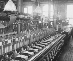
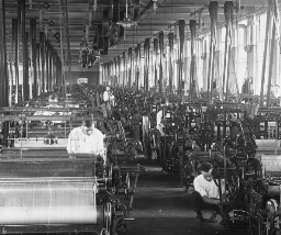
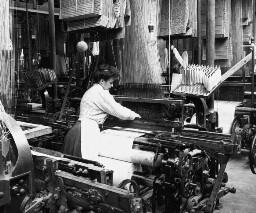
Weaving Linen Fabric, Montreal, Canada
After the bobbins are filled they are sent to the weaving room. You can see a number of looms busy weavin When sugar beets are pulled, their tops are cut off, and their roots are stacked in great piles. Sometimes these piles are made in the fields where they are grown, and the beets are hauled later to the sugar factory. Such piles are to be seen frequently in Colorado, where there is little rainfall. The heaps are often higher than a man's head, and cover large areas of ground. The roots must be stored indoors before frost comes. They usually are hauled to the factory, where they are dumped into bins such as you see. The beets here have been unloaded from freight cars, into the storage shed. The bins inside these sheds are V-shaped. At the bottom of the bin are little canals through which a stream of water runs to carry the beets to a large washing drum. This drum is partly filled with water. As it turns over and over, the beets are thoroughly washed. You will observe that this pile consists of tons and tons of beets. They are larger than the garden beet, and more irregular in form. They look here somewhat like huge, pointed sweet potatoes. The channel in which the water flows is directly beneath the little valley that extends between the beet ridges the entire length of the shed. After the beets are washed they fall into a chute which carries them to the floor below. Here they drop into a huge slicer, equipped with large knives that revolve from 100 to 150 times a minute. These cut the beets into strips or slices. Different methods are used in different factories to extract the juice from the slices. In some factories the pieces are run through presses, and the juice is squeezed out the same way that cider is squeezed from apples. But there is a less expensive way shown in view 271. The processes of weaving linen are much the same as those of weaving cotton goods. Our great-grandmothers spun by hand many fine pieces of linen for dress goods, and for great-grandfather's pantaloons. The spinning was done on spinning wheels run by the foot. Cloth was woven on hand looms. The methods of weaving in our large factories to-day are much the same as those our great-grandmothers used. One set of linen fibers runs to the loom length-wise. This is called the warp. It is the threads of the warp that you see coming down from the floor above. Each of these threads passes through an eye fastened to a pair of heddles. Each thread then runs between fine wires, set in a narrow, oblong frame. These wires are called reeds. The eyes and the reeds prevent the threads of the warp from becoming tangled. Linen is made as other cloths are made, by shooting the threads of woof cross-wise through the threads of the warp. As one of the heddles lifts its set of threads, the shuttle bearing the threads of the woof travels across between the layers. Then the first heddle drops, and the second rises. The threads of the woof are again shot across. In this way, the fabric is woven very smoothly and very rapidly. They are some linen factories in the United States and in Canada, but the greatest of these are in Europe. Throughout the Netherlands, France, Austria, Great Britain, and Ireland are large linen mills. The linens of Belgium are especially fine. Here are made laces and handkerchiefs. France excels in cambrics and lawns. Keystone ID: 20932 Note: All titles, descriptions, and location coordinates are from the original Keystone Slide documentation as supplied by the Keystone View Company. No text has been edited or changed. -
Wawona Tree, Mariposa Grove, Yosemite Valley
The Yosemite National Park contains three groves of sequoias (s-kwoi´ås) , the big trees of California. One of the trees is 204 feet high and 292 in diameter. The one you see is not so large as that. The sequoias are of two species, the big trees and the redwoods. The big trees are the largest and oldest trees in America. Many of them are in the Sequoias National Park on the upper slopes of the Sierra Nevada Mountains and in the General Grant National Park six miles distant. In these two parks are 1,660,000 sequoias. Twelve thousand of these are more than ten feet in diameter. Many of the largest ones have been named. There is a General Sherman tree, a General Grant tree, an Abraham Lincoln tree, a George Washington tree, and so on. It takes a long time to determine exactly the age of these trees. This is done by counting the rings from the heart to the bark. On one of the old, fallen trees, John Muir (mr), the naturalist, counted 4,000 rings. The oldest living thing in the world is the General Sherman tree. Because it is standing, it is impossible to count the rings, but it is probably 3,500 years old. In other words, it was a little bush 1,500 years before the time of Christ. It was a small sapling when the Pyramids of Egypt were built. The sequoias are not only big and old, but they are also stately. They are regularly formed, and the trunks do not have branches on them for the first 100 or 150 feet from the ground. Then great, stubby limbs shoot out from all sides. It is a cone-bearing tree, and its foliage is therefore feathery and very thick. Its bark is cinnamon-brown in color. Keystone ID: 5006 Note: All titles, descriptions, and location coordinates are from the original Keystone Slide documentation as supplied by the Keystone View Company. No text has been edited or changed. -
Wash Day, Nice, France
Nice (ns) lies on the Riviera (r-vyâ´ rä) or that part of the Mediterranean (md -tr-´ n-n) between Cannes (kån) and Genoa (jn´ -å). It is a noted winter resort. It is a city of 150,000 population, well situated on a broad bay. It is divided into two sections by a stream. On the one side is the old section of the town. The new part, on the other side, is called the Strangers' Quarter. Here are the homes of the winter comers. The Old Town is of more interest to us than is the fashionable section. Most of the streets are narrow. You would call them alley-ways or narrow lanes. Here dwell the natives of Nice. Here was born the famous Italian patriot, Garibaldi (gä´ r-bäl´ d). The stream that flows through Nice is one of its interesting features. In dry weather it is only a slight creek with a broad stony bed. But it is a treacherous bit of water. It rises in the mountains back of Nice and flows down the slopes to the sea very rapidly. Heavy rainstorms often occur in these mountains. Immediately the creek becomes a torrent. Woe then to the boatman who pays no attention to weather; or worse yet to the dozens of women washing clothes in the creek. The flood sweeps over everything in its path. Many women have thus been drowned. Now there is a watcher who signals a rise in the river. When the danger signal appears, there is a scramble for the upland. You might think this scene an unusual one even for Nice. It is not. You are not visiting here on a Monday! Any week day is a washday in Nice. The peasant women carry their bundles of clothes to the side of the stream, and proceed with the washing. Great clothes lines are set up on the banks, and these lines are usually filled with garments. Keystone ID: 11766 Note: All titles, descriptions, and location coordinates are from the original Keystone Slide documentation as supplied by the Keystone View Company. No text has been edited or changed. -
Wall Street, City of New York
Wall Street runs in an easterly direction from Broadway, directly opposite Trinity Church. You are here looking westward towards the church. To the right of you in the immediate foreground is the United States Sub-Treasury Building with the statue of Washington in the front. To the left, in the foreground, is the New York Stock Exchange. The street is the money center of the United States. You will recall that the Dutch settled on the extreme southern end of Manhattan Island. To protect themselves from the attacks of the Indians and the English, they built a wall across the island from east to west. Wall Street occupies about the same ground upon which this wall stood. The United States Sub-Treasury Building was erected as the Custom House for the Port of New York. It stands on the ground where once stood the City Hall and the Government Buildings of the English Colony of New York. That is, at this spot was the capital of the province. At the close of the Revolution, the United States Capital was New York, and the Capitol Building was the present Sub-Treasury Building. It was here that Washington took oath of office as the first president of the United States on April 30, 1778. Inside the building you may still see the brown-stone slab upon upon which he stood when Chancellor Robert R. Livingston, of New York, administered the oath. Trinity Church is the home of an Episcopal Congregation that was organized in 1697. It occupies land that was given the congregation by the Crown of England. The present building was erected in 1846. About the church is a burial ground, famous because it contains the remains of Alexander Hamilton, Robert Fulton, and Captain Lawrence. Tell about Hamilton, Fulton, and Lawrence. Keystone ID: 1009 Note: All titles, descriptions, and location coordinates are from the original Keystone Slide documentation as supplied by the Keystone View Company. No text has been edited or changed. -
Waiting Their Turn at the Cotton Gin, Greenville, Texas
After the cotton is picked it is loaded into wagons and hauled to gins. At the gins the seeds are taken out and the cotton lint or fiber is pressed into bales ready for shipment. On some large plantations, where modern machinery is used, gins are also set up. The cotton is hauled from such estates directly to the shipping point, in bales. The common practice, however, is such as you see here. Here is a group of farmers waiting their turn at the village cotton gin. "First come, first served," is the rule here just as it is in the North where farmers haul their wheat to the mills. The loose cotton, as you see, is tramped into a wagon box, and is hauled probably for several miles over country roads. In many places these roads are far from good. You would know this by looking at the mud on the legs of the horses and the mules, and on the wagon wheels. The man with the stiff hat is probably the purchaser for the gin. He examines the cotton, takes particular note of its length of fiber, and tells each farmer how much he will pay per pound for his load. The wagon is then driven on scales and the weight of the wagon is subtracted from the weight previously found out. The difference leaves the number of pounds of cotton in the load. Texas easily leads all other Southern States in the production of this crop. It annually produces about 4,500,000 bales. What is the total value of this crop at 10 cents per pound? Name six or seven states in the cotton belt. Observe the dress of the men seen here. How do you account for their wearing wool hats in this warm climate? Keystone ID: 9508 Note: All titles, descriptions, and location coordinates are from the original Keystone Slide documentation as supplied by the Keystone View Company. No text has been edited or changed. -
Wagon Used to Haul Ammunition to Perry, 1813
Great Britain for a number of years prior to 1812 had been forcing Americans to serve on her ships. This at last led to war. We fared miserably in land battles. The Capitol at Washington was burned by a small British force; and until Jackson's triumph at New Orleans, we had no land victory to compare with Saratoga or Yorktown of the Revolution. But on the water, we proved a match for the "Mistress of the Seas." British commerce was so worried by American vessels that England was at last ready for peace. One of the greatest defeats to the English navy was on Lake Erie. Oliver Hazard Perry and 50 ship carpenters built a fleet of 9 vessels at what is now Erie, Pa. Guns and ammunition had to be hauled overland, for the British fleet controlled the Great Lakes. The covered wagon here pictured was used to haul some of this ammunition. It is of the Conestoga (Con´ es-to´ ga) type, in which settlers used to travel overland to take up new homes. With his new fleet Perry attacked the British fleet on September 10, 1813. During the battle Perry's flagship was so badly damaged, he had to row in a small boat to another of his vessels. Broadside after broadside the Americans sent into their enemies. One British ship after another was disabled, until Captain Barclay hauled down his flag as a token of surrender. You know the famous message Perry then sent to General W. H. Harrison: "We have met the enemy and they are ours: two ships, two brigs, one schooner, and one sloop." Read an account of Perry's Victory on Lake Erie. Why did people travel overland in covered wagon? What were the lines of travel to the West? Keystone ID: 16729 Note: All titles, descriptions, and location coordinates are from the original Keystone Slide documentation as supplied by the Keystone View Company. No text has been edited or changed. -
Volcano in Eruption, Java
Any opening in the earth that throws up hot rock and steam is a volcano (vl-k´n). Usually a volcano builds up a cone-shaped peak about its crater (kr´tr), as the mouth of the opening is called. A volcano is said to be "active" when it explodes from time to time. These explosions are called eruptions (-rp´ shn). They sometimes wipe out whole cities several miles from the peak. What causes eruptions like the one you see here? We know that the inside of the earth, or at least parts of it, are very hot. This heat causes gases to form and these after a time explode. A study of the view shows the result. In the upper left corner is an area of steam. Dense smoke, ashes, and cinders make up the heavier parts of the eruption. Melted stone, called lava, pours over the edge of the crater and runs down the sides of the cone. The built-up peak stands out clearly like a mound of ice. Many volcanoes are quiescent (not active) for years at a time. Then rumblings are heard inside for days or months, until finally an eruption takes place. What famous volcano is in the Mediterranean Sea? There are volcanoes in North America but most of the active ones are in Mexico, Central America, and the West Indies. Many islands in the Pacific have been thrown up by volcanic upheavals. Java is an island in the East Indies. Find it on the map. It belongs to the Netherlands. Much of the soil is volcanic ash, and is very rich. Rice, sugar, coffee, tea, tobacco, cotton, maize, and indigo are grown on the large plantations. Its chief mineral is tin. Java is slightly larger than Pennsylvania, but it has almost one-third as many people as the whole United States. Keystone ID: 16400 Note: All titles, descriptions, and location coordinates are from the original Keystone Slide documentation as supplied by the Keystone View Company. No text has been edited or changed. -
Vineyards, Mendoza, Argentina
The province of Mendoza is in the western tier of states in Argentina. Its most westerly part is made up of the highest portions of the Andes Mountains. Out of the foothills the land is a level or rolling plain. Parts of Mendoza might almost be called "Little Italy" on account of the vineyards and the people. Here one finds not Spanish or Portuguese, as in so many places in South America, but Italians. They were brought up in the vineyards of Italy, and they are employed to tend the vines of Mendoza. The land is usually held by rich Frenchmen, and the Italians are their workers in the fields. The land has to be irrigated from the streams that rise in the mountains. You can see here an Italian family resting at the noon hour. Beyond them stretch the long rows of well-kept vines trained on wires. Men, women, and children labor together in the fields. This mother has stretched a blanket over a rope to keep her baby out of the sun while she works. When the grapes are ripe, old and young, men and women, take their baskets and pick the fruit. The grapes are sent to winepresses where the juice is squeezed out. One of the big industries of Argentina is wine making. The grape crop of the country is valued at $10,000,000 a year. Most of the fruit and the wine are shipped to Buenos Aires (bw´ ns i´ rs) in special trains. Many of the wealthy owners of the Mendoza vineyards live in Buenos Aires during the southern winter; that is, during May, June, July, August, and September. But when the southern summer begins to come they go to Paris. Thus they have winter the year round, and live where social life is always busy. What other countries of the world are noted for grape growing and wine making? Keystone ID: 21818 Note: All titles, descriptions, and location coordinates are from the original Keystone Slide documentation as supplied by the Keystone View Company. No text has been edited or changed. -
View of Stockholm, Sweden
Before you is a bird's-eye view of the capital of Sweden. A part of the water front of the city is to your right. And what looks like the street is more nearly a bridge; for there is water to the extreme left also. All about the city are waterways. For this reason Stockholm is called the "Venice of the North." But the Venice of Italy is built on piles. Stockholm is set upon natural granite. Water and stone abound in Sweden. One acre out of every twelve in the whole country is water, and the granite breaks out in its highlands. Stockholm is an important seaport on the Baltic. Like many other Baltic ports its waters are frozen in winter; but many flags fly in its harbor in the shipping season. The city is the seat of government and an educational center for the country. It has many factories, cotton and linen mills, iron foundries, and sugar refineries. It is about the size of New Orleans. Do you know what we get from Sweden? Its forest supply matches, woodenware, and paper, and its mines furnish high-grade iron. The Swedes are a thrifty, hard-working people. They raise many cattle and sheep, and make butter and cheese. Potatoes, rye, sugar beets, and oats are grown on the small farms. Stockholm is an old city. Its history can be traced for more than 700 years. Out of the gates of its ancient castles marched many armies to battle against the Germans, the Danes, or the Russians. Under two of its kings, Sweden was one of the chief powers of northern Europe. Then Stockholm was the queen city of the Baltic. Keystone ID: 13000 Note: All titles, descriptions, and location coordinates are from the original Keystone Slide documentation as supplied by the Keystone View Company. No text has been edited or changed. -
View of Printing Room, Cotton Mills, Lawrence, Mass.
The gray cotton cloth that comes from the loom is singed over a gas flame to make it smooth. It is then bleached to make it white. The next process is coloring or designing it. Special artists paint attractive designs which are copied on zinc plates and transferred to copper rollers. Only that part of the design that is in one color is out on a roller. Enough rollers are needed to cover all colors the design calls for. These rollers are supplied with the proper colored inks. As they revolve they print the white cloth as it speeds under them. Great care must be taken to see that all colors are properly registered. That is, that part of the design on each copper plate must fall exactly where it belongs or the colors will overlap. The view shows the enormous extent of one of these printing rooms. You will observe the printed cloth coming over. A foreman is here seen inspecting a bit of the print. After it is printed the cloth is run over large copper cylinders filled with steam. The steam dries the inks. The cloth is next folded down in great piles. It is then soaped and washed to make it clean. Again it is drawn over steam cylinders to dry it. It is then starched and stretched and dried-all by special machines. Then comes the calendering, or ironing, if the cloth is to be smoothly finished. If the cloth is not to be smooth, it is run through a napping machine which scratches the surface till it is fuzzy. After the goods have been ironed or napped it is folded, measured, and put on bolts containing 35 or 40 yards of cloth. The factory you have seen in this view finishes about 5,000,000 yards each week. This means that enough cloth of different widths is here made in a year to reach around the world 6 times. Keystone ID: 22083 Note: All titles, descriptions, and location coordinates are from the original Keystone Slide documentation as supplied by the Keystone View Company. No text has been edited or changed. -
View of Ore Unloader at Work, Conneaut, Ohio
On the right is a lake steamer laden with ore from the Lake Superior district. It is at the docks alongside an unloader. This unloader is only a huge steel framework with a number of tracks extending on one side over the dock, and on the other side over the switches. The trucks on these overhead tracks are equipped with buckets which dip the ore out of the hold of the vessel. The bucket is pulled by an engine, up to the truck to which it hooks. This releases the truck, which travels to the other end of its tracks, and there the bucket is lowered and emptied. The view shows one car on the right being loaded. The truck on the left is dumping its bucket of ore into the freight car. Four series of cars can be loaded here at the same time. The hoist, or steel framework, is 60 feet high and 180 feet long. The bucket is of the type called clam shell. The steel cars into which the ore is dumped are shaped inside like hoppers. That is, their bottoms are sloped. When these cars reach the steel mills, the hopper is opened at the bottom and the ore is dropped into bins below the tracks. Each car can carry 50 tons of ore, and on the return journey will carry 38 tons of coal. You will observe lying on blocks of wood on the ground, two pairs of steel cables. Each of these cables is slowly moving. When it is necessary to move the car, or the series of cars, to shift them under the buckets, a chain is attached from the cable to the car. When the car has been brought into the proper position the chain is unhooked. What is meant by the Lake Superior district? Explain briefly how the unloaders work? Where is Conneaut? Keystone ID: 6697 Note: All titles, descriptions, and location coordinates are from the original Keystone Slide documentation as supplied by the Keystone View Company. No text has been edited or changed. -
View from Lookout Mountain
This view from Lookout Mountain is most wonderful. From its top on a clear day seven states may be seen. To the eastward, you can see the mountains of Virginia and North and South Carolina. To the south lie Georgia, Alabama and Mississippi. Northward are the green fields of Kentucky. At its base lies the Tennessee River, its shining water winding in great double curves through a broad alluvial flood plain covered with rich farms and woods. The river is navigable for eight months of the year. Almost encircled by the river lies the busy city of Chattanooga. Unlike most southern cities, Chattanooga is a manufacturing center. In 1911 it adopted a commission form of government. In the far background, Missionary Ridge towers up against the sky. This lovely place was the scene of one of the decisive battles of the Civil War. After their defeat at Chickamauga (Chk´å-mô´gå), the Union forces under General Thomas took their station at Chattanooga where they were besieged by the Confederates under General Bragg. Grant and Sherman came to the rescue of Thomas. On November 23, 24 and 25, 1863, the great battle was fought. The Confederates held all the highlands. Up the mountain sides swarmed the men in Blue, up, until the clouds hid them from the view of the people below. Above the clouds the battle raged fiercely. When the Northern armies won the top of the slope the Confederates retreated. On the lower slope of Lookout Mountain may be seen the memorial cemetery where the soldier dead lie buried. Notice the cumulus clouds in the sky. What is a meandering stream? Keystone ID: 23082 Note: All titles, descriptions, and location coordinates are from the original Keystone Slide documentation as supplied by the Keystone View Company. No text has been edited or changed. -
Victoria Falls, Rhodesia, Africa
The Zambesi (zåm-b´ z) River rises on the border of Congo Free State in Central Africa. It flows southwest for 600 miles at a height of almost a mile above sea level. In Rhodesia it breaks out of the central highlands in the Victoria Falls. These Falls are much larger than Niagara Falls. The amount of water that pours over them in a year is probably greater than goes over Niagara in the same time. And the falls are much higher and wider. The waters of the Zambesi plunge downward about 400 feet over the rocks, and the river here is over a mile wide. The thunder of its downpour can be heard for miles away. Add to the grandeur of the falls the richness of a half-tropical plant life on the shores and the glory of the place is made much greater. In some ways, however, the Victoria Falls are not so grand as the Niagara. The spray is so heavy over the Zambesi that the view is shut off a little distance away. At the Niagara Falls one can get a slight of the whole wonder at one time. Then, too, during the dry season the Victoria Falls do not have enough water to cover many of the rocks. In the wet season the water is muddy. The water at Niagara is clear, and it does not vary a great deal in amount during the year. The famous missionary and explorer, Livingstone, discovered Victoria Falls in 1855. Just above the falls, in the distance, you can see the island on which Livingstone landed when he first saw them. Just below the falls a railway bridge spans the gorge. It was built in 1905. It is an eighth of a mile long, and is over 400 feet above the water. Find out all you can about Livingstone's travels in Africa. Locate the following waterfalls: Yosemite; Yellowstone; Niagara. Keystone ID: 17004 Note: All titles, descriptions, and location coordinates are from the original Keystone Slide documentation as supplied by the Keystone View Company. No text has been edited or changed. -
Vew of Burgos, Spain
You know something of Spanish history because it is linked closely with early American history for 3 centuries. You will recall that Ferdinand and Isabella were ruling Spain when Columbus asked their aid to go in search of the Indies. The marriage of Ferdinand and Isabella led to the union of two powerful Spanish houses. Castile and Aragon were rival kingdoms. Ferdinand was a king of Castile and Isabella was from Aragon. After the union of these two houses, Spain soon became a united country. The history of the city of Burgos is the history of old Castile. It is a very old city. Spanish tales relate that it was founded in 884-over a thousand years ago. It was for a long time the capital of old Castile. In 1087 the capital was moved to Toledo, and the glory of Burgos departed. But its great past could not be taken from it. It is the very center of Spanish story because here the national hero lived. He is called the Cid (that is, the Lord). He was born in Burgos about 1025, and was a skilled leader of soldiers. His greatest feats were the capture of Toledo and Valencia. He was to Spain what Alfred the Great was to England, although the two men were utterly different. In Burgos the Cid is buried, and much of the romance of the city clusters about his name. Today Burgos is a city of over 30,000 people. It is the capital of a province, and here dwells an Archbishop. Burgos is on the railway line that connects Paris and Madrid (mä-drd´). It is one a treeless, windswept plateau, through which a small river flows. Its climate is severely cold in winter and extremely hot in summer. Its chief claim to a traveler's attention is the fine Gothic Cathedral. Locate Burgos. What mountains are near it? Read the article about Castile in an encyclopedia. Keystone ID: 15814 Note: All titles, descriptions, and location coordinates are from the original Keystone Slide documentation as supplied by the Keystone View Company. No text has been edited or changed. -
Vecchio Bridge Across the River Arno, Florence
About midway between Rome and Venice in the interior of Italy is the city of Florence. It is one the River Arno which empties into the Mediterranean at Pisa (p´sä). Florence is a city of about 350,000. Many famous men have come from Florence, among whom are Dante (dn´t) the great writer, Michelangelo (m´ kl-n´j-l) the great artist, Galileo (gl´-l´) the astronomer, Amerigo Vespucci (vs-pt´ch), from whose name America is derived, was Florentine. Florence is recognized as the art center of Italy, not only because of the superb masterpieces of painting and sculpture which attract art lovers from all the world, but also because of its artistic productions of the present day. It is noted for its university, its art galleries and its schools of music and art. The Ponte Vecchio is one of the sights of the city. It connects the Uffizi with the Pitti Palace, both filled with priceless works of art. Every foot of available space is given over to little shops, most occupied by goldsmiths. In the Middle Ages it was a common custom to give the bridges in the center of a city the trade. The Vecchio is one of the few survivals of this custom. Florence was a village a hundred years before the time of Christ. During the Middle Ages it was an important independent city and controlled the neighboring towns, even capturing Pisa. Florence reached its height in the fourteenth and fifteenth centuries when the family of de' Medici (d md´-ch), rich bankers, controlled the government of the city. The city was made a part of the kingdom of Italy in 1859, and for five years served as the capital of that country. What city is now the capital of Italy? Keystone ID: 1952 Note: All titles, descriptions, and location coordinates are from the original Keystone Slide documentation as supplied by the Keystone View Company. No text has been edited or changed. -
Ute Indian and Family, Colorado
This view is worth your careful study for many reasons. First of all, you will be interested in the Indian man mounted on his pony, with the rope tether at his side. He is a straight, square-shouldered person, a good type of the Ute (t) tribe. As in common with these Indians, he wears his hair in two braids, one hanging on the front of either shoulder. You will notice, too, that, unlike white plainsmen, he does not wear tall boots. He has his feet encased in Indian moccasins. The Indian woman, as is the custom of this tribe, lets her hair hang loose. Over her shoulders is a woolen shawl, woven in a pattern common to western Indians. But perhaps the figure of most interest is the Indian baby fastened in his upright cradle. Not much of his face can be seen under his large hat, but he appears to be enjoying his living quarters as much as if he were in a fine crib. The Ute Indians belong to the Shoshone (sh sh´ n) tribe, which formerly lived in the region from Oregon and Idaho almost to the Gulf of Mexico; and from Montana to the Pacific. It is believed that they are related to the Aztecs, and came from beyond the Rio Grande River. The Utes themselves lived in parts of Colorado, New Mexico, California, and Utah. This last state gets its name from the Indians. When the white men found them, these Indians were powerful warriors. They were such expert horsemen. They were the terror of the California gold seekers who crossed the plains. It was a fight for life when the Utes attacked a wagon train. At the present time the Utes live on reservations (rz´ r-v´ shn) chiefly in Nevada, Utah, and Colorado. The reservation in which this view was taken is in a strip of country along the southwestern boundary of Colorado. Keystone ID: 8082 Note: All titles, descriptions, and location coordinates are from the original Keystone Slide documentation as supplied by the Keystone View Company. No text has been edited or changed. -
United States Warships, San Diego Bay, Calif.
The leading nations of the world have great fleets of war vessels to protect themselves from enemies. The most powerful fleet in the world is the British navy. Great Britain is an island country with many colonies in distant seas. The country, therefore, depends on her battle fleet to protect her possessions, and to keep enemies from molesting her shipping, or from invading the country. The United States is in a somewhat similar position. Our country is not an island country. But we expect no serious difficulties with either of our two neighbors, Canada and Mexico. If the United States has war with a power as strong as itself, this war will be with a nation across the seas. For that reason we have built, and are building, powerful ships of war. The backbone of a fighting fleet is its battleships. These ships are armed with heavy guns that have a fighting range of 10 to 15 miles. Battle cruisers are the speedy vessels especially fitted to prey upon enemy commerce. Destroyers make it their business to watch for submarines, and to protect the battleships from submarine attacks. The submarine is the most recent, and in many ways, the most remarkable vessel afloat. It can travel long distances under the water, can come to the surface at will, and can submerge in a very brief time. It is equipped with a periscope (pr´ -skp), through which observations on the surface of the water can be taken, without the submarine coming entirely to surface. Many submarines are equipped with guns, but their chief weapon is the torpedo. In the Great European War, Germany used submarines to attack enemy fleets and to destroy commerce. Keystone ID: 16667 Note: All titles, descriptions, and location coordinates are from the original Keystone Slide documentation as supplied by the Keystone View Company. No text has been edited or changed. -
United States Troops in Review, Sydney, Australia
In 1908 the battle fleet of the United States made a tour around the world. Far-away Australia was visited in August of that year. In honor of the event, a grand military review was held in Centennial Park, in Sydney. Twelve thousand Australian troops, consisting of field artillery, blue jackets, the Scottish Rifles, the Garrison Artillery, the Light Horse Brigades, and others, passed in front of the reviewing stand here shown. In the stand with the Australian officials were the American commanders. The place of honor in the marching columns was given the American sailors. Two hundred and fifty thousand people witnessed the review, to do honor to their own soldiers and to pay their respects to their visitors. Sydney was rightly selected for such a demonstration. It is the chief port and largest city of Australia. It is about the size of Boston. Its harbor is one of the finest in the world, rivaling those of Constantinople (kn-stn´ t-n´ pl), Rio de Janeiro (r´ d zhå-n´ r), and San Francisco in beauty. The city is built on the side of a broad peninsula (pn-n´ s-lå), formed by two rivers and Botany Bay. The high shore line of one of these rivers is deeply indented by sawtooth inlets that form natural ports. On two of the tongues of land, formed by the inlets, the city has been built. The harbor equipment is of the best. There are large storage buildings for grains and wool, and buildings for freezing meats. The city appears to the traveler to be older than it is because of its narrow, winding streets. Some of these are very steep, since Sydney is built among the hills. Its chief thoroughfare is two miles long. Victoria Park, here shown, is one of the city's show places. Keystone ID: 15962 Note: All titles, descriptions, and location coordinates are from the original Keystone Slide documentation as supplied by the Keystone View Company. No text has been edited or changed. -
U. S. S. Missouri in the Panama Canal
One of the reasons the United States wanted the Panama Canal built was to get our war vessel from our east coast to our west, or the other way round, in a short time. By using the Canal our fleet can be rushed from one side of our country to the other in a month's less time than if it had to go around Cape Horn. In the Spanish-American War the battleship Oregon was on our Pacific coast. We needed it to help the fleet fight the Spanish ships in the West Indies. The Oregon had to sail alone entirely around Cape Horn before it could be of service. The Panama Canal can be used by the ships of war of any nation. But the United States has built large forts to keep enemy ships out in time of war. Three million dollars are being spent to fortify it. Cannon of 6-inch, 14-inch, and 16-inch caliber have been put in the forts. There are also 12-inch mortar guns. With such cannon as these, the canal ought to be reasonably well defended. The battleship Missouri, which you see in the view, is the first war vessel to go through the Canal. It must have been a proud group of sailors on board this vessel to have had such an honor. The ship is in Gaillard cut. How far is this from Colon? From Panama? Europe in the 15th and 16th centuries sent many ships to find the "northwest passage" to China and India. The Panama Canal is this famous "northwest passage." And the battleship Missouri is the warship to which the glory of being first belongs. Find out all you can about the voyage of the Oregon from the Pacific to the Atlantic. Who were some of the early sailors that sought the northwest passage to China and India? Keystone ID: 21781 Note: All titles, descriptions, and location coordinates are from the original Keystone Slide documentation as supplied by the Keystone View Company. No text has been edited or changed. -
Tropical Scene, Brazil
You are here looking at a mountain just back of Rio de Janeiro (r´ d zhå-n´ r). It is called Santa Theresa Mountain. It is not a high mountain, but from its top one can have a wonderful view. At its foot lies the capital city of Brazil. Beyond the city is the harbor almost encircled by land. You can see a part of Rio, the harbor, and the hills beyond. But the mountain has beauties of its own. Its clumps of sub-tropical trees; its white houses, perched on its slopes; its cooling winds-these are restful to the tired city dweller. It is easy for the people of Rio to get to the top of this mountain. A cable railway runs over it, and directly to the heart of the city. There is a fine hotel on the way up the mountain. There is one thing of interest here to the student of history. Three hundred years ago the Jesuit priests built an aqueduct (k´ w-dkt) down the mountain. It carried water to the city from springs on the slopes. It still carries water to Rio. But there are many other aqueducts to help it now; for Rio is a city of a million people. Brazil is a large country. It is almost as large as the Dominion of Canada, and has 3 times as many people as Canada has. It would make about 60 states the size of Michigan. It lies mostly in the tropics. The Equator crosses its northern part. This section is drained by the Amazon River and its tributaries. Along the Amazon much of our raw rubber is gathered. On the southeastern coast coffee is the chief crop. Four of its states produce two-thirds of the world's supply of coffee. The natural wealth of Brazil has scarcely been touched. It has rich forests that have hardly been explored. With the exception of a few states, agriculture has scarcely begun. Manufacturing is yet in its infancy. Keystone ID: 21851 Note: All titles, descriptions, and location coordinates are from the original Keystone Slide documentation as supplied by the Keystone View Company. No text has been edited or changed. -
Tramming Copper-bearing Rock, Calumet, Mich.
The ancients were noted workers in copper and brass. In fact they knew some arts connected with working these metals that our modern scientists have been unable to discover. For example, we do not know today how to temper copper so it will make cutlery; but the ancients did this regularly. On the other hand, we have thousands of uses of copper that the early people never dreamed of . Today our telephone telegraph, and cable systems depend on a core of copper wires to carry their messages. Our whole scheme of electric lighting, street cars transmission plants, electric railways, and our automobiles all call for copper. One of the most famous copper mines in the world is the Calumet-Hecla in the upper peninsula of Michigan. Find Calumet. There is a large deposit of copper here in the old glaciated rocks. The remarkable thing about this deposit is that some of the copper is pure; that is, it is mined in large pieces of copper unmixed with other elements. The Indians knew of this copper for some of it cropped out on the surface. They worked it for some of their ornaments. Now this vein is tapped by shafts, one of which is 5,700 feet long. Another taps the lode 2,543 feet below surface. Another shaft is 4,800 feet straight up and down. The copper-bearing rock is drilled by machines, and blasted loose by dynamite. The mine is stoped; that is, cut into steps or ledges so it can be worked at different layers. These stopes are tapped by slanting chutes into which the rock is put. The rock slides down into the tram cars such as you see here. What are the heavy timbers for? How would you like to work a mile underground? Keystone ID: 22037 Note: All titles, descriptions, and location coordinates are from the original Keystone Slide documentation as supplied by the Keystone View Company. No text has been edited or changed. -
Tractor at Work Near Lima, Peru
In the southern portions of Peru in the rich valleys farming is carried on extensively. The most common crop, because it is the most profitable, is sugar cane. This cane is grown on large plantations, called haciendas (hä´ s-n´ dä). These are owned chiefly by rich landholders, but sometimes by companies of men. The natives do the labor at so much a day. You will note that modern machinery is used to make the soil ready for planting. Here is a tractor hitched to a narrow and a pulverizer. You will observe that the harrow is fastened between the two sets of wheels. The revolving pulverizer or steel roller is attached behind the second pair of wheels. This tractor is made somewhat differently from the ones commonly used in our fields. This does not have its own power. The power is furnished by an engine at the end of the field, which draws the machinery back and forth by means of a cable. You can see the large disk upon which the cable winds. The engine is located directly ahead of the tractor at the other side of the field. Cane was brought into Peru by the Spaniards. It was formerly tended in an old-fashioned manner by hand. Now most of the sugar estates are fitted up with modern machines similar to the one you see here. More then that, most of the haciendas have little railroads upon which the harvested cane is loaded and hauled to the crusher. There the sap is crushed from the stalks and is boiled down into the form of raw sugar. The annual production of sugar in Peru amounts to more than 175,000 tons. This large amount is grown on a small percentage of the soil that is fitted for sugar production. The soil is so rich that the cane is cut several times every year. Keystone ID: 21869 Note: All titles, descriptions, and location coordinates are from the original Keystone Slide documentation as supplied by the Keystone View Company. No text has been edited or changed. -
Tower of London. London, England
This is one of the most interesting buildings in London. If the Tower on London could only talk, it could tell most of the history of England from the time of William the Conqueror. One part is said to have been partly built by Julius Caesar. The Tower for centuries was the chief state prison of England. Here were kept the prisoners who were traitors or who were disliked by the King or Queen. Here, too, these prisoners were put to death. In one of the cells Sir Walter Raleigh was imprisoned by King James. Raleigh carved his initials on the walls of this cell, and these are still to be seen. It was here he wrote his History of the World. You remember he was finally beheaded by King James. Dukes, earls, counts-men of all ranks-have been thrown into this prison, and many of them never came out alive. The Tower is on the Thames River, and one of the gates to it on the river is called Traitors' Gate. Through this gate state prisoners were taken into the Tower. The Tower is now used as a barracks. There are stationed here soldiers called The Yeomen of the Guard. They wear the costume of King Henry VIII, and are generally termed "beef-eaters." In the Tower also are kept the jewels of the King and Queen and the robes used at the coronation. Here, too, are many fine relics such as suits of armor, swords, guns, the headsman's axe and block, etc. One of the sits of armor is that of the Earl of Leicester, the man who figures so largely in Scott's Kenilworth. What prisons do you know in your state? Read Dickens' Tale of Two Cities for a good story of prison life. Keystone ID: 2111 Note: All titles, descriptions, and location coordinates are from the original Keystone Slide documentation as supplied by the Keystone View Company. No text has been edited or changed. -
Tokyo, Japan
Tokyo, Japan
Here you have a view of Tokyo (t´ k-), the capital of Japan. Locate it on the map. It is on the Tokyo Bay, but this bay is landlocked. It therefore it not a port. Its port is Yokohama, 18 miles away. It is, however, one of the great cities of the world. In population it is the sixth largest city in the world. London, New York, Paris, Chicago, and Berlin only are greater in size. In contains over 2,000,000 inhabitants. Tokyo has been an important city in Japan for a long time. It was the seat of the government before there was a Mikado (m-kä´ d) or an Empire of Japan. It was then called Yeddo. The palace of the Emperor stands where the castle of the earlier rulers stood. The palace is in beautifully laid out grounds. Near it are the Parliament buildings, for the government of Japan, in form, is somewhat like that of England. In the business section of the city the houses are crowded together closely, and the streets teem with people. The city is only 10 miles long and 8 miles wide, and the houses are low. We know from this that the buildings are close together to hold 2,000,000 persons. Observe the heavy tile roofs. These keep the houses from being blown down by the typhoons. The houses themselves are generally slight buildings. Tokyo has an elevated railroad, electric lights, and street cars. It is the railroad center of Japan. It is about the size of San Francisco. Osaka is the next city in size after Tokyo. It is 3 times as large as Yokohama. Locate all the cities mentioned. What countries in Asia does Japan control? Japan has been called the "Great Britain of Asia." Why should it be so named? Keystone ID: 14032 Note: All titles, descriptions, and location coordinates are from the original Keystone Slide documentation as supplied by the Keystone View Company. No text has been edited or changed. -
Tokay Grapes in California Vineyard, Acampo, Calif.
Here you are in the greatest grape-producing area in the United States. Note the luxuriant growth of the vines and the fine, big clusters of fruit that hang between each clump. These are the Tokay grapes from which a well-known brand of wine is manufactured. California easily leads all other states of the United States in the production of grapes. In fact it produces nearly as many as all the rest of the states put together. New York ranks second. Its great grape-raising area is called the Chautauqua Belt. This is along Lake Erie, and extends not only through sections of northern New York, but also through northern Pennsylvania and northern Ohio. This westward stretch is really a part of the basin of Lake Ontario which has been filled in naturally. A goodly part of the New York grapes is made into wine but in California the wine varieties and the raisin varieties are about equal. You know that raisins are only sun-dried grapes. California wines are widely known, but since France is the great wine country of the world, most of the California brands are given a French name. Such fine varieties of the wine grape as the Scuppernong and the Catawba are descendants of the wild grapes native to North America. The Tokay variety and many other varieties were imported from Europe. If you turn back the pages of history you will find that the grape is one of the oldest plants cultivated. The Egyptians had their vineyards as did also the Greeks and the Romans. The Romans brought the vine to England, and did much to promote the growth of grapes in France. The first vineyard in this country was set out by a Frenchman in 1610 at Jamestown. Keystone ID: 16747 Note: All titles, descriptions, and location coordinates are from the original Keystone Slide documentation as supplied by the Keystone View Company. No text has been edited or changed. -
Tobacco Field, Kentucky
The United States is by far the greatest tobacco-producing country in the world. In 1915 our country produced more than 1,000,000,000 pounds. Russia, the second important tobacco growing country, produced, in 1913, about one-fifth of this amount. Austria-Hungary and France follow in this order. Among the crops of the United States, tobacco now takes seventh rank in value. Among the crops of the world it ranks ninth in value. Tobacco is grown in many of our states. Kentucky easily leads all others in its production. In 1915 the crop of the state amounted 356,400,000 pounds. North Carolina ranked second, with 198,400,000 pounds. Virginia came third, with 144,357,000 pounds; Ohio stood fourth, with 84,330,000 pounds; Tennessee was fifth, with 69,657,000 pounds. Here is one of the fields in the famous Kentucky tobacco-growing district. Tobacco seeds are sown in hotbeds or in cold frames, and the small plants are set out by hand or by machines. This transplanting takes place in April, May, or June, depending on the latitude. The rows are from 3 to 4 feet apart and the plants are variously spaced in the hills. Sometimes they are set as close as 1 1/2 feet. Other times they are twice this distance apart. The young plants are cultivated just as corn is. Before the bloom appears the tops are broken out in order that the strength of the plant may be forced into the leaves. The mature plants are from four to six feet high. Tobacco is harvested either by cutting the stalks or by breaking the leaves off. The leaves are hung in large barns where they are cured. You see a great number of these barns in the distance. Tobacco is a native of America. The Indians were smoking the weed when Columbus discovered the Western Continent. Keystone ID: 20092 Note: All titles, descriptions, and location coordinates are from the original Keystone Slide documentation as supplied by the Keystone View Company. No text has been edited or changed. -
To the Clouds By Rail, Mt. Pilatus, Switzerland
Mt. Pilatus is admired by all travelers in Switzerland. It is really a series of 10 mountain peaks all rising from the same general base. These stretch in an east and west direction. The highest peak is almost 7,000 feet. The Esel is next to the easternmost of the 10 peaks. It is up the Esel that this train is climbing. The railroad was built to take tourists to the top for a fine view over Lake Lucerne and the nearby mountains. It was made ready for use in 1889. A Swiss by the name of Lochern was the chief engineer. The road begins at Alpnachstad on Lake Lucerne. It ends on top of the Esel. Its length is about 3 miles. In going these 3 miles, the train rises over a mile above the starting point. No ordinary train could make such a climb. It was necessary to build a cog railroad. A cog rail with teeth on both sides catches the cogs on the wheels. In this way the train is pushed upward or let downward. The train consists of an engine and one coach, forming a single car with only two axles. There are seats for 32 people. Eight trains run daily. It takes an hour and 25 minutes to go up, and an hour and 20 minutes to go down. The fare up is 10 francs; down 6 francs. You see the train far up on the steep side of the Esel. Here the track appears to hang over a terrible cliff. The train passes through 4 tunnels. One of these you see. It looks like a black hole in a wall. To the left the clouds are playing about a mountain peak. Do you know of any other fine pieces of railroad making or bridge building? How much is a franc worth in this country? Of what great mountain system is Mt. Pilatus a part? Keystone ID: 10770 Note: All titles, descriptions, and location coordinates are from the original Keystone Slide documentation as supplied by the Keystone View Company. No text has been edited or changed.
Showing 1-50 of 543 records.