
Records
Your search returned 543 Results
Refined by : tiff scanned file from original glass slide
- Iconographic browsing
- Results per page : 20
-
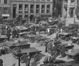 A Busy Market Square, Copenhagen
A Busy Market Square, Copenhagen
The scene before you gives some notion of the reason for the name of the capital city of Denmark. The word "Copenhagen" (k´pn-h´gn) means "merchants' harbor." And here are buyers and sellers a-plenty in this busy old city. Can you make out what is for sale? Copenhagen is an ancient, island city. A thousand years ago a fishing village stood where the present city now is. The village grew because the harbor is one of the finest on the Baltic Sea. Besides, it is at the western end of the Baltic, and receives ships going into and out of this northern ocean. In time the king of the Danes made it the capital of his country. Now it is a city larger than San Francisco. It is built on two islands separated by a stretch of water called the Haven, where the shipping lies. Here are ships flying the flags of all nations. And here too, are large shipbuilding ways where the vessels are being constructed. The Dames have always been a seafaring people. They invaded England; and Iceland and Greenland are still their colonies. In addition to its commerce, the city is noted for its porcelain works, breweries, sugar refineries, and cloth factories. Much of its trade is carried on with Norway, Sweden, Germany, and Great Britain. The city was once the home of a famous sculptor named Thorwaldsen. One other Dame you probably know about. He is Hans Christian Andersen, the author of fairy tales. The soil of this little land is poor and the climate is severe in winter. Dairying, poultry raising, and sugar beet farming are the chief occupations in the country. Keystone ID: 13082 Note: All titles, descriptions, and location coordinates are from the original Keystone Slide documentation as supplied by the Keystone View Company. No text has been edited or changed. -
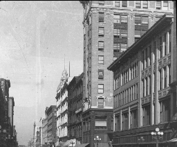 A Busy Street in Minneapolis, Minn.
A Busy Street in Minneapolis, Minn.
Minneapolis sprang up at the Falls of St. Anthony on the Mississippi. Not many years ago Minnesota was noted for its lumbering. The Falls of St. Anthony furnished power to drive the machinery of great sawmills and planing factories. When the lumbering ceased to be so important, agriculture took its place. In a few years there were miles of wheat fields on the prairies, particularly in the valley of the Red River of the North. Today Minneapolis is the greatest flour making center in the world. North Dakota, South Dakota, and Minnesota grow a great deal of flax. This is raised for its oil. Minneapolis is the center of this trade, so it has great linseed oil factories. Linseed oil is made from flax seed. It is used to mix with paint. The seeds are crushed, the oil is pressed out, and the seedcakes are fed to farm animals. Minneapolis and St. Paul are so near each other they are called "The Twin Cities." Together they are the greatest railroad center northwest of Chicago. Minneapolis has 4 transcontinental railway lines and 9 railway systems Seven lines connect it with Chicago, 6 of which end in Minneapolis. The city has broad, clean, well-lighted streets. Nicollet Avenue, shown in the view, is the chief retail thorough fare and one of the finest streets in the city. Minneapolis has a fine park system, containing nearly 4,000 acres. In one of these parks is Minnehaha Falls, which you have read about in Longfellow's Hiawatha. The state university is also in Minneapolis. It is one of the largest universities in our country. Minneapolis is the largest city in Minnesota. It has a population of over 300,000. Which way is it from Chicago Keystone ID: 16703 Note: All titles, descriptions, and location coordinates are from the original Keystone Slide documentation as supplied by the Keystone View Company. No text has been edited or changed. -
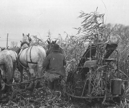 A Corn Harvester at Work in Indiana
A Corn Harvester at Work in Indiana
Corn is a double food supply for stock. The grain is one of the best foods known for horses, cattle, sheep, and hogs. And the stalks and leaves when cured take the place of hay and straw both as food and bedding. On many, perhaps most, small farms, corn is cut by hand. When it begins to ripen in September men cut it several inches above the ground and set in shocks. It is then spoken of as corn fodder. On damp days during the fall or winter the shocks are torn apart, and the corn is husked. The fodder is reshocked, and is hauled out of the field as it is needed for food. But corn cutting by hand is slow and hard work. It takes a strong, quick field hand to cut 30 shocks, 12 hills square, in a day. Hence, a machine was invented to cut corn more rapidly and with less labor. You see here one of these corn harvesters at work. The machine is built to cut but one row at a time. The corn is caught between two slanting uprights and a sickle cuts it off. It is tied in bundles at the same time, and these bundles fall from the rear of the harvester. All the workman needs to do is to drive his team properly. The bundles may be hauled to barns or silos for storage or they may be set in shocks, in much the same way wheat is handled. This machine does not husk the ears. The first of these harvesters that were operated did not meet with favor. They knocked off too many ears of corn. This objection has been partially overcome. At any rate it is no great task to pick up the fallen ears in field where the corn has been so harvested. And there is a great saving in labor and in time by using machinery instead of men. Keystone ID: 16712 Note: All titles, descriptions, and location coordinates are from the original Keystone Slide documentation as supplied by the Keystone View Company. No text has been edited or changed. -
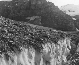 A Crevasse in the Victoria Glacier, British Columbia
A Crevasse in the Victoria Glacier, British Columbia
On the Canadian Pacific Railway, about 100 miles west of Calgary, is the Rocky Mountain Park of Canada. This is a reservation (rz´ r-v´ shn) of the Dominion Government. It contains about 5,000 square miles. It is sometimes called the Canadian Yosemite. It has many mountains from 8,000 to 10,000 feet in height, a number of hot springs, and one of the most beautiful lakes in the world, Lake Louise. Within its limits are many wild animals such as deer, caribou, (kr´ -b), bears, elks, wild goats, and long-horned sheep. The reservation includes some of the finest glaciers in North America. Here you are on one of these great ice sheets on the side of Mt. Victoria. In the background you see the peaks of Mt. Lefroy and Mt. Victoria. Directly in front of you is wide crevasse (kr-vås´) with sheer sides of solid ice. You see the snow crystals glistening in the bright sunshine. A misstep here would send you into the bottom of the deep, ice-bound precipice. When mountain climbers come to a crevasse such as this, and can find no way around it, a ladder must be constructed to make the crossing. If the chasm (kz'm) is narrow enough for the guide to leap it, a rope ladder can be made to bring the party safely over. Mt. Victoria is a peak 11,400 feet high. It takes skillful mountain climbers from 7 to 9 hours to make the ascent. It was first climbed in 1897. It is a dangerous climb because of the snow and because of the crumbling, overhanging rocks on some of the paths. Mt. Lefroy is 11,290 feet high. It is more difficult to climb than Mt. Victoria. One of its passes over which the ascent is made is called the Abbot Pass, after a mountain climber who there lost his life. Keystone ID: 13830 Note: All titles, descriptions, and location coordinates are from the original Keystone Slide documentation as supplied by the Keystone View Company. No text has been edited or changed. -
 A Fishing Village, Netherlands
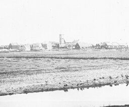
A Fishing Village, Netherlands
Open your geographies to the map of Netherlands. You see that the sea has bitten out of the center of it a great mouthful of land. This stretch of water is called Zuider Zee. "Zee" in Dutch means "sea.." Ages ago the sea covered a large part of the land we now call Netherlands. Then the waters lowered. Sand dunes were piles up with great arms of the ocean running far into the land. But the rivers brought down soil and filed up the channels. Then the Dutch came, and they set to work to help Nature out. They built dikes like the sand dunes, and pumped water back into the ocean. Thousands of acres in Netherlands have thus been captured from the sea. The work is still going on. The Zuider Zee is being drained and filled in from year to year. Some day the Zuider Zee may not be on the map of Holland. You are looking at one of the flat islands of this inland sea. It looks to be scarcely above the water's edge. Not a tree in sight. The houses of the little fishing village are huddled together as if they were afraid. The people, at least, have one great fear hanging over them. This is that the sea may rush in during a storm and flood their land. But the fishermen are bold. To the northwest is one of the greatest fishing grounds in the world. Here the Dutch trawlers go for their catch. They are manned by hardy sailors as bold as Hendrik Hudson. Perhaps the Dutch have fought the sea so long they are naturally its masters. At any rate their vessels have explored all parts of the world. Dutch colonies are in both Americas and in the far-away East Indies. The Dutch East India Company has played as important a part in the history of commerce as that of the Hudson Bay Company of the English. What did Hudson discover? Keystone ID: 6436 Note: All titles, descriptions, and location coordinates are from the original Keystone Slide documentation as supplied by the Keystone View Company. No text has been edited or changed. -
 A French Winter Resort, Cannes
A French Winter Resort, Cannes
You may be unable to find the city of Cannes (kån) on your map. It has a population of only 35,000, yet it is widely known in Europe. It is famed as a winter resort. It lies on the gulf of the Mediterranean, northeast of Marseilles (mär-slz´) and southwest of Nice (ns). The coast here is called the Riviera (r-vyâ´ rä). The Riviera runs from Cannes to Genoa. The Alps close in on the west and the Appenines of the east. Here during the winter months come hundreds of persons to escape to cold of Paris, London, or Berlin. The climate of this section is semitropical and very healthy. The slope is southerly, and the warm winds from northern Africa make it pleasant in midwinter. People of Europe go to Cannes in the winter just as people of the northern United States go to Palm Beach or Los Angeles. The city has many fine villas with beautiful gardens about. Most of these houses are built of white marble quarried from the nearby hills. Cannes is a city of flowers. On the hill slopes back of it some 60,000 acres are set to flowers from which perfume is made. There are orchards of fig trees, olives, peaches, oranges, almonds, and lemons. The gardens about the houses are bright with flowers and the blossoms of semi-tropical trees. The harbor is small and is used chiefly by private yachts (yôt), sailboats, and launches. Some of these you can see here. Boating and bathing are the popular pastimes of the wealthy. Nearby are many beautiful islands that make excellent picnicking grounds. There are a few historic spots in Cannes that are worthy of note. One of these is an old church 600 years old. There are also the ruins of a castle, and a tower. From the tower one can have a fine view of the city and the harbor. Keystone ID: 11760 Note: All titles, descriptions, and location coordinates are from the original Keystone Slide documentation as supplied by the Keystone View Company. No text has been edited or changed. -
 A Highland Home, Scotland
A Highland Home, Scotland
You have here a view of a peasant's house. Such houses can be found throughout the length and breadth of Scotland. Most of them are built in the same way. That is, their walls are made of stones or bricks, and their roofs of thatch. Simple as they are, though, they are very pleasing to the eye. In the summer time the walls of the houses are covered with vines and the little gardens next the houses show the Scotchman's love of thrift and natural beauty. The view shows more than the mere outside of the house. Here are two Scotch women each of whom is more than three score years. They are having their afternoon cup of tea and are doubtless chatting over the affairs of their little village. They sit prim and erect at the little tea table on chairs that are as prim and erect as they are. Their lives have been led entirely, perhaps, within the valley in which they now live. Beyond the mountains you see in the background lies a world unknown to them. They often speak of the country beyond the neighboring hills as "over yonder." The Scotch have long been known as a hardy people. They are honest, fearless, and simple in their ways of living. They are straightforward and frank. It is said that a Scotchman would not tell a lie to save his head. But he can be, and usually is, a courteous gentleman. Their simple ways of living have been taught them by the very country in which they live. It is generally rough and the crops are not large. Life becomes to these country dwellers a simple matter, and they become, like their hills, rugged, erect, and clean-cut. Scotland has given to the world some of its greatest thinkers, especially in engineering, science and medicine. It has also furnished great statesmen and warriors. Its three great authors you know very well. They are Carlyle, Scott, and Burns. Keystone ID: 12702 Note: All titles, descriptions, and location coordinates are from the original Keystone Slide documentation as supplied by the Keystone View Company. No text has been edited or changed. -
 A Hippopotamus Hunt, Mlembo River, Rhodesia, East Africa
A Hippopotamus Hunt, Mlembo River, Rhodesia, East Africa
The word "hippopotamus" (hp-p-pt´ å-ms) means "river horse." As you can readily see, these animals are much larger than horses, and the river is their home. Here you see an American hunter in Rhodesia, Africa, resting after a busy morning with his rifle. He has bagged three large hippopotamuses. The natives who are with him are happy. There is a great feast ahead, for the meat of the hippopotamus is a food they relish. The skins, too, are valuable, so that the hunt has been a profitable one. The hippopotamus is a queer-looking animal. Its great body is set on four stubby legs each of which spreads out into four toes. Its feet are partly webbed. Its head is wider below the nostrils that at the ears. Its little ears are rounded, and have a flap inside to keep out the water. The nostrils project out from the snout so the animal can breathe while swimming by merely sticking his nostrils above the water. The nostrils can also be closed by inside flaps. The big body is not covered by hairs, but has only a few bristles. Ugly and ungainly though he is, the hippopotamus is well made to live in swamps and rivers. The animals are huge in size. Their bodies are often 14 feet long and 3 1/2 feet high. They live on plants, and feed at night. They are sleepy, stupid animals in daytime. They swim lazily about in the rivers, or sink to the bottom to tramp about, coming to the top of the water from time to time to breathe. The mother hippo is very fond of her baby. She watches over him kindly and carefully and takes him swimming on her back. From whom did Rhodesia get its name? What animal resembles the hippopotamus most? Keystone ID: 17012 Note: All titles, descriptions, and location coordinates are from the original Keystone Slide documentation as supplied by the Keystone View Company. No text has been edited or changed. -
 A Japanese Garden
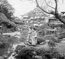
A Japanese Garden
Here is Japan at its best. This is an example of the beautiful park gardens in which the Japanese delight. It has all the elements of natural beauty-water, rocks, woods, and hills. But these elements have been combined artistically by skilled hands and eyes trained to beauty. The Japanese are artists by taste and by training. The children see beauty all about them from their birth. Their homes are clean, neat, and tastefully decorated. In school they are taught art. They learn how to put colors together that harmonize. They are taught to decorate in colors and to lay out gardens and grounds beautifully. They know the shrubs, the flowers, and the value of water, trees, and birds in making a beautiful garden. Do you know any of the trees or shrubs in the picture? What kind of birds do you find? How do the dresses of the girls harmonize with the scene. This picture is worth your careful study if you are interested in either art of nature. If you know, or care to learn, anything about taking pictures, this view will also appeal to you. What is there about it that shows its photographer was an artist? In a good photograph where should the chief figures be? What are the chief figures in this view? This view illustrates another trait of the Japanese. They are extremely clean. There is no dust or dirt in their houses. Their parks have no papers lying around. Their clothes are clean. And they pay particular attention to the cleanliness of their bodies. Every house has its little round bathtub. Public baths are in all centers of population. The Japanese take from two to five baths daily. They love cleanliness for the joy of being clean. Americans can learn much from the Japanese, but we can learn nothing finer that the habit of cleanliness. Keystone ID: 14047 Note: All titles, descriptions, and location coordinates are from the original Keystone Slide documentation as supplied by the Keystone View Company. No text has been edited or changed. -
 A Japanese Shoe Shop
A Japanese Shoe Shop
If you have never seen a Japanese clog, you will be interested in this picture. All these flat boards with their horseshoe-shaped uppers are shoes. And you can buy a pair for 10 cents. The price depends on the kind and the finish of the wood, and the quality of the uppers. The lad on the stool has a pair of clogs on, so you can see how they are worn. The Japanese sock has a separate "stall" for the great toe. The thong that fastens the uppers to the wooden soles rests between the great and the second toes. Clogs are therefore easy to remove, and this is one reason the Japanese like them, for they do not wear their shoes in the house. Clogs are also good to keep the foot of the wearer from becoming damp. Japan has such heavy rainfall in the summer that this is a decided point in favor of clogs. But they are cold, noisy on the streets, and tend to flatten the feet. What kind of shoes did the American Indians wear? You will recall, however, that Japan like many other eastern countries has few animals. Leather is scarce. Therefore shoes had to be made in early times from some materials the Japanese had at hand. The simple wooden sole with the simple upper came into use. Clogs are not unlike the sandals of the Greeks and Romans. They are easier to remove, but are not so neat as the European sandal. The wooden shoe of the Hollander you have seen, or at least know about. In Japan many American shoes have been sold in recent years. The Japanese in the United States have no trouble with our shoes. They object chiefly to the fact that our close fitting shoes "make feet smell bad." How is the leather obtained that is in our shoes? Where are most of our shoes made? What does pair of your shoes cost? Keystone ID: 14058 Note: All titles, descriptions, and location coordinates are from the original Keystone Slide documentation as supplied by the Keystone View Company. No text has been edited or changed. -
 A Japanese Tea Gatherer
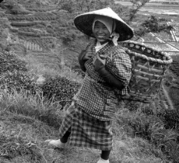
A Japanese Tea Gatherer
This view is worth your study for a number of reasons. It gives you an idea of the way the farming country of Japan looks. It also shows tea growing on terraces, or leveled places on hillsides. And not least it furnishes a close view of the dress of a country girl of Japan. You will notice that the rice fields in the valley are laid out like little gardens. They are tilled like gardens, too. Labor is plentiful. In fact Japan has more people than it can very well support. It is necessary then that no land is allowed to remain idle if it can be tilled. If a bad year for crops occurs, many people must go hungry. What other countries have a dense population? Observe the fine tea bushes just back of the girl. Tea grows best in a sandy loam. The shrubs need plenty of moisture but they cannot stand too much water. For these reasons the finest tea plantations are found on the lower slopes of hills. There are the sandy loam and a plentiful soil water. The valleys may be flooded by the heavy rains, but the lower hillsides are well drained. However, in this view tea is grown on terraces. It is uncommon to see such a plantation. This is one of the sections that is known to the Japanese as a producer of fine teas. The fields you see are in Shizuoka, about 30 miles southwest of Fujiyama. Most of the finest tea that Japan grows is not exported. The Japanese are such lovers of the drink they keep the best tea for home use. The girl is full-grown. How tall do you think she is? Do you see anything queer about her eyes? Her hat looks like a toadstool. Of what do you guess it is made? Notice her shoes. How are they fastened to her feet? Why does she not have gloves that cover her fingers? What part of the tea shrub will she carry back in her basket? Keystone ID: 14739 Note: All titles, descriptions, and location coordinates are from the original Keystone Slide documentation as supplied by the Keystone View Company. No text has been edited or changed. -
 A Load of Logs Near Kettle River Landing, Minnesota
A Load of Logs Near Kettle River Landing, Minnesota
In this scene you are near Kettle River, Minnesota, about 50 miles southwest of Duluth. Formerly a large part of the state of Minnesota was covered with rich forests. In the northeastern section were the great pine areas. South of the pine district were the great woods in which were spruce, tamarack, oak, birch, and poplar. The lumbermen were the first to settle in the state, and its early development was due to the lumber industry. Now, however, most of the valuable timber has been cut. But more than one-fifth of the area of the state is still timbered. In 1913 the lumber output of Minnesota amounted to 1,149,704,000 feet. The forests of the United States have been one of our greatest assets. We sometimes think that most of our timber has been removed, but still 1/4 of our country is in woods. Our forests formerly covered about 850,000,000 acres, by far the richest forested areas of any other like size in the world. We are now cutting trees at the rate of three times the annual growth. This means that our forested areas are decreasing very rapidly. Every year we use about 90,000,000 cords of wood for fuel; about 40,000,000,000 board feet of lumber; 450,000,000 board feet for veneer; 135,000,000 ties; 1,500,000,000 staves, to say nothing of the wood used for pulp, mine timbers, excelsior, telegraph and telephone poles, etc. The men here shown have brought down from the hillside a great sled load of logs. Observe the way in which the sled is built. It is made in two sections so that the front runners can be turned to Kettle River and floated to the mill below where they will be sawed into lumber. Keystone ID: 20033 Note: All titles, descriptions, and location coordinates are from the original Keystone Slide documentation as supplied by the Keystone View Company. No text has been edited or changed. -
 A Mountain Chalet, Grindelwald, Switzerland
A Mountain Chalet, Grindelwald, Switzerland
The word "chalet" (shå-l´) means "cottage". The term is now used chiefly to mean Swiss cottages. These are built in one general style. The lower story is of stone. The upper story is of wood. The roof is made of shingles and projects far out over the house. Where the country is rough, and mountain floods are common, the roofs are weighed down with stones. Sometimes a torrent breaks over a mountain side and plunges into the valley. Then the houses need to be strong and the roofs solid. The view shows an ideal Swiss scene. Against the side of the cottage is stacked a pile of wood. This is to be used for fuel, perhaps for cooking. The pile will be much larger before winter comes; for huge fires are needed to drive out the cold in these mountains when the now falls. In the little out-house are stored supplies of food. The narrow road winds up the valley past another farm house. It looks like a ribbon unwound among the foothills. The little field is strongly fenced. You would call it only a garden. Most Swiss fields are only gardens in size. Only a small part of the land is tillable, but it is carefully tended. Every village has its herdsman who drives the cattle each summer morning up the mountain sides where the pastures are green. In the distance the picture shows the white cap of an Alpine peak. The snows on its top are everlasting. In the valley are trees that shed their leaves in the fall. Beyond and higher to the right you will observe the evergreens. Beyond these the trees are only shrubs. Then plant life disappears, and the line of snow is reached. Generally speaking, wild animal life also stops with the line of vegetation. There are a few exceptions to this, however. Keystone ID: 10702 Note: All titles, descriptions, and location coordinates are from the original Keystone Slide documentation as supplied by the Keystone View Company. No text has been edited or changed. -
 A Nightingale on Her Nest, England
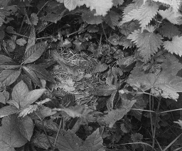
A Nightingale on Her Nest, England
Perhaps no bird has figured in poetry so often as the nightingale. It is the bulbul of the Persian poets. It has been a favorite theme of English poets from Chaucer to Keats. Its song is sweet and full of melody, and carries a long distance. The fact that is sings after night, when all else is still, has made it popular. Here is a part of a poem that Keats wrote about it, as he listened to its night song through his open window. The bird is described as flying from one thicket to another far away: Adieu! adieu! thy plaintive anthem fades, Past the near meadows, over the hill stream, Up the hillside, and now 'tis buried deep In the next valley-glades: Was it a vision, or a waking dream? Fled is that music:-Do I wake or sleep? It is the male bird that sings. He sings in fine weather in the daytime as well as at night. He can be heard only from early May to the middle of June, for he sings only till the young are hatched. The nest is begun in the early part of May. The birds of the species you see here are to be found only in central Europe and Africa. They go to Africa for the winter. In the spring they return to their summer haunts. They prefer thick woodsy spots in damp places. The nightingale is not a large bird. From the bill to the tip of the tail it measures only a half foot. What bird do you know of about the same size? It has a brownish back, and a buff-colored breast. Its eggs are generally brown. From 4 to 6 are laid in the nest. Of what is the nest built? Is it near the ground? Make a list of birds that nest on the ground; in bushes; in trees. How would you go about to take the picture you see here? Keystone ID: 21200 Note: All titles, descriptions, and location coordinates are from the original Keystone Slide documentation as supplied by the Keystone View Company. No text has been edited or changed. -
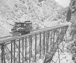 A Railway Bridge in Peru
A Railway Bridge in Peru
This is the Cofa bridge on the Oroya ( r´ yä) railway. It is built across a steep valley in the Andes (n´ dz) Mountains in Peru. It is, perhaps, no more wonderful than other bridges on this railway, for the Oroya railroad climbs to a point higher than any other railroad in the world. It starts at Callao (käl-yä´ ) on the Pacific Ocean, and rises to the height of 15,665 feet. And this climb is made in a little over 100 miles! Imagine Pike's Peak at Albany, N.Y. A train then in going from the city of New York to the top of Pike's Peak would not climb quite so rapidly as the Oroya trains have to do all the time in going up from Callao. There are tunnels-some fifty of them-that open out on bridges at a height that makes one dizzy. There are great peaks all about, rising into the land of eternal snow. When one looks at the bridge shown here, he wonders how the road was built. An engineer from the United States laid out the railway. He solved the problems of tunnels, bridges, curves, and cuts. The railroad is a monument to its builder-Henry Meiggs. The road starts from Callao, the chief port in Peru, and one of the four great ports on the western shore of South America. It runs to Lima, tha capital of Peru, 6 miles from the coast. Then it climbs eastward into the mountains to cities whose names are very hard to pronounce, and to rich mines. It is easy to build railways in level country. This is one of the reasons that the United States has the greatest railway systems in the world. Western South America has few railroads because of the Andes Mountains. Only one line extends across the continent. Locate Callao; Lima. What other great bridges to you know of? Keystone ID: 21811 Note: All titles, descriptions, and location coordinates are from the original Keystone Slide documentation as supplied by the Keystone View Company. No text has been edited or changed. -
 A Russian Peasant Plowing
A Russian Peasant Plowing
Russia is a backward country in its industries. The peasants are not educated, and do their work in the same way and with the same tools that their grandparents did. In this view, the Russian farmer is turning the soil with a plow at which an American farmer would laugh. It is an old-fashioned, home-made, clumsy affair. It does not turn the top soil under properly, as you see. The harness of the horse is in keeping with the plow. In spite of poor farm machinery, Russia is an agricultural country. It buys most of its manufactured goods from other nations. It produces four-fifths of the flax of the world; one-fifth of the wheat and the sugar beets; and one-tenth of the cattle. Rye, barley, oats, hemp, and potatoes are widely grown. The bread of the peasant is made of rye flour. The farmer you see here may own this land; but he does not own it in the way we use the term. Each village and city holds the land for its peasant population. Every year the fields are parceled out to the village dwellers. But the ground is worked in common, and the people usually work together. At harvest times the crops are divided among the people by the village officers. The only part of the land the peasant really controls is a small garden on which his house sits. The government and the wealthy class hold much of the country in large estates. Russia has the greatest natural resources of any country in Europe. It has long stretches of fine farming land. It is rich in minerals of many kinds. Its forests are hundreds of miles in extent. None of these resources have yet been developed. Tell how plowing is done on the farms in your neighborhood. What is a peasant? Of what is your bread made? Keystone ID: 18101 Note: All titles, descriptions, and location coordinates are from the original Keystone Slide documentation as supplied by the Keystone View Company. No text has been edited or changed. -
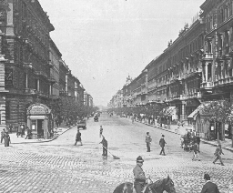 A Street in Budapest, Hungary
A Street in Budapest, Hungary
Hungary, a part of the Empire of Austria-Hungary, would make 3 states the size of Ohio. It is an agricultural country. Its principal crops are corn, wheat, barley, oats, and rye. Grapes are widely grown, and much wine is made. Tobacco and hops are important field crops. Its orchards produce apples, apricots, peaches, pears, and plums. Its forests are extensive. Oak, beech, and pine are its valuable trees. The mines and factories of Hungary are its other sources of wealth. Iron, coal, gold, and silver are the chief minerals. It manufactures clothing, foodstuffs, machinery, glassware, leather, chemicals, sugar, flour, and liquors. Budapest is the capital of Hungary. It is 160 miles southeast of Vienna, the capital of the Empire. The city is built on both sides of the Danube. On the right bank is Buda, a much older city than Pest, on the other side of the river. The two cities united in 1872. Pest is now much larger than Buda, and is a more modern city in all respects. Budapest has a population of about 880,000. Three-fourths of these speak the Magyar (md´ yr) tongue. The street you see here leads from the center of Pest, on the Danube, to the Town Park, 2 miles distant. It shows the extent of the city, and its fine buildings all of the same height. The height of all buildings is regulated by law. Near the spot you are standing are the fine Parliament Buildings. The city has many factories, and is especially noted for its flouring mills. It is sometimes called the Minneapolis of Europe. Why? The wheat grown in Hungary is of fine grade, and Budapest flour brings high prices in the European markets. The city was the first capital in Europe to use electricity for lighting and for driving street cars. Keystone ID: 15656 Note: All titles, descriptions, and location coordinates are from the original Keystone Slide documentation as supplied by the Keystone View Company. No text has been edited or changed. -
 A Street in Jaipur, India
A Street in Jaipur, India
Jaipur is the strangest city of the whole East. In Eastern cities one comes to expect narrow streets, running in any direction. Most large Eastern cities have some fine, broad, straight streets or avenues, but this is not the rule in the case of most of the highways. They were laid out without any plan. The cities have grown in any way the dwellers saw fit to build them. In Jaipur conditions are different. Jaipur was built in 1728 by a native ruler of the same name. He was a great scholar in mathematics and astronomy, and he had ideas on building cities. He laid out his capital carefully after a set plan. The main streets are all 111 feet wide and straight as a line can be drawn. The cross streets are also straight and cut the main streets at right angles, just as most of the streets in American cities do. The streets are all paved and curbed, and have broad sidewalks. They are lighted by gas. All this makes Jaipur look like a Western city in the Eastern world. But here the likeness stops. The buildings in the pictures appear to be of stone. They are not. They are built of stucco painted pink to imitate sandstone. This makes the city look unreal. Travelers liken it to a painting of a city on a theater stage. What makes it appear still more unreal are the people, their dress, and the vehicles to be seen on the streets. Hindus, camels, push-carts-all that go to make up an East Indian city are there. Jaipur is a city of 175,000. It is 150 miles southwest of Delhi. Name all the ways of traveling shown here. Would you know from the view that Jaipur is not an American city? If so, how? Do the streets of the cities you know cross at right angles? What are avenues? Keystone ID: 12560 Note: All titles, descriptions, and location coordinates are from the original Keystone Slide documentation as supplied by the Keystone View Company. No text has been edited or changed. -
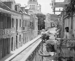 A Street Scene in Guayaquil, Ecuador
A Street Scene in Guayaquil, Ecuador
Ecuador is one of the small countries of South America. It is about the size of the state of Arizona and has a population of 1 1/2 million. It is the only country in the world named after an imaginary line. The Equator cuts the country into two parts, and it is from this word that the name of the country comes. It is the last country southward in the wester tier of countries in South America that is supplied with rain. Its capital is Quito, but its chief city is Guayaquil. Guayaquil is situated on the gulf of the [san?] name. This gulf is the outlet of the Guayaquil River, the largest river on the western coast in South America. It is a city with a population of 80,000, making it about the size of Des Moines. Guayaquil imports annually from the United States and Europe over $10,000,000 worth of products. It exports an equal amount of goods consisting of coffee, rubber, hides, and cocoa. Guayaquil is one of the wettest and most unhealthful cities in the world. The country surrounding it is flooded during the rainy season each year. Many of its streets are dirty and many of the houses are built of bamboo laths so that they will not be toppled over by the frequent earthquakes. This is one of the most beautiful sections of the city. The white houses with their [d?] tiled roofs, taken together with the spires of the churches, make a pleasing picture against the background of hills. The little Spanish maiden is posing for her picture. The country is naturally very rich in its forests, its soil, and in its minerals. None of these [?] worked properly, so that the whole country does not produce as much as a small New England city. Keystone ID: 21872 Note: All titles, descriptions, and location coordinates are from the original Keystone Slide documentation as supplied by the Keystone View Company. No text has been edited or changed. -
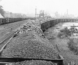 A Trainload of Coal from Pittsburgh Fields for Lake Superior Consumption, Conneaut, Ohio
A Trainload of Coal from Pittsburgh Fields for Lake Superior Consumption, Conneaut, Ohio
There is nothing unusual about this scene. On almost any of the great railways in the eastern and middle western sections of our country such trainloads of coal as this can be seen any day. But there is a particular interest connected with this and similar trainloads of coal running from the Pittsburgh district to the Great Lakes. Our greatest iron ore deposit lies at the western end of Lake Superior. In this district, however, there are no coal fields. One of two things must be done. Either coal must be taken to the ore fields, or the iron must be brought to the coal fields. Coal is needed to heat the iron so that it can be made into steel. When the Lake Superior iron district was first worked, all the ore was carried by huge lake boats to the coal district. But by this method, these boats had to return empty. This was a great waste. Now the shipping is carried forward both ways. Iron and steel refineries have been built in the Superior District. The vessels that bring iron ore to the east, carry back heavy cargoes of coal to be used in the Superior iron district. This trainload of coal that you see will be put on board one of these ships and unloaded at Duluth or Superior, not far distant from the iron ore area. This makes the ports along the southern shore of Lake Erie the natural exchange place of coal and iron. Among these important ports are Buffalo, Erie, Cleveland, Toledo, Ashtabula, Lorain, and Conneaut, the city here shown. Locate each of these cities on your map. Trace a shipment of coal from Conneaut to Duluth. Through what waters does it pass? Keystone ID: 6705 Note: All titles, descriptions, and location coordinates are from the original Keystone Slide documentation as supplied by the Keystone View Company. No text has been edited or changed.
Showing 1-20 of 543 records.